This post is part of a draft on South Siberian language homelands and Sprachbünde.
The following text contains a description of Pre- and Proto-Samoyedic stages and its dialectal diversification. Contacts with Indo-Iranian, Yeniseian, Tocharian, Yukaghir, and Turkic, as well as onomastics and palaeolinguistics are taken into account to pinpoint the succeeding homelands and expansion territories. The archaeological-archaeogenetic discussion is focused on the Middle Bronze Age Cherkaskul materials of the Andronovo period, on the Late Bronze Age Karasuk culture, and on the evolution and expansion of the Iron Age Tagar culture within the framework of “Scytho-Siberian” groups.
- Pre- & Proto-Samoyed
- Areal linguistics
- External contacts
- Proto-Indo-Iranian & Iranian
- Yeniseian & Tocharian
- Yukaghir
- Turkic, Mongolic & Tungusic
- Palaeo-Siberian & Palaeo-Arctic
- Hydrotoponymy
- Palaeolinguistics
- Archaeology & Population Genomics
PLEASE NOTE. Many of the Y-SNP calls from ancient samples referred to below have been analyzed by the FamilyTreeDNA Haplotree team formed by phylogeneticist Michael Sager and Göran Runfeldt from the R&D team. Those ancient samples with validated haplogroup inferences are marked by a hyperlink to the FTDNA Haplotree. Occasionally, though, such hyperlinks are also used in the text when discussing Y-SNP branches in general, without referring to specific ancient samples. For a quick reference of ancient samples, you can check out the Ancient DNA Dataset, also visually in an Online Web Map, in SNP Tracker, or in AncientDNA.info. TMRCA and formation dates have been checked from YFull.
1. Pre- & Proto-Samoyed
Proto-Samoyed shows a limited number of reconstructible lexemes, probably around 1000 words based on the works by Janhunen (1977) & Aikio (2002, 2004), i.e. substantially less than all other known intermediate Uralic dialects. This is related to the lack of sufficient sources of dialectal Samoyedic lexicon, but possibly also to the high age of this proto-language within the family (Saarikivi 2020: 48-49).
Samoyed languages show more variation than Finnic, Samic, or Permic languages, believed to have diverged in the Iron Age or later, which sets a relative terminus ante quem for the diversification of Proto-Samoyed. On the other hand, given the certainty in the reconstruction of a complex system of distinguishable Proto-Samoyed inflectional suffixes – unlike those for Ugric, assumed to have separated ca. 2000 BC, if not earlier – it is likely that Proto-Samoyed reflects a language that diverged early in the first millennium BC (J. Pystynen, p.c. in Piispanen 2018:359).
1.1. Areal linguistics
While Nganasan shows more archaic features, most areal variation is found within southern groups, i.e. Selkup and Sayan Samoyed. The extinct but well-described Mator language (Helimski 1997) in particular is notably different from other attested Samoyed languages, although it is unclear to what extent this is due to its strong Yeniseic substrate (see below). All this suggests that the older variation has disappeared due to language shift of ancient Samoyedic speakers to Turkic and Russian (Saarikivi 2020: 51).
NOTE. Juho Pystynen recently announced that Tamás Janurik has been uploading papers to his Academia.edu account, among them two multilingual ‘documental-comparative’ dictionaries of Kamassian (Kamassz szótár) and Koibal (Kojbál szótár). Further research on extinct Samoyed languages might bring about changes to the PU reconstruction.
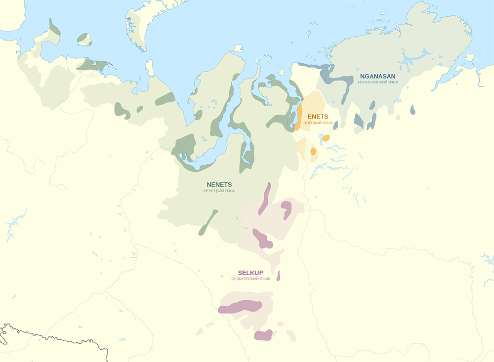
The Nenets have an oral tradition concerning Sikhirtja, the population preceding them in their present area, which has been considered an account potentially referring to pre-Uralic groups inhabiting the Arctic coast (Stipa 1990: 66-67).
Reindeer herding likely caused the spread of Tundra Nenets and replacement and assimilation of earlier smaller groups, similar to how Evenki, Yakut, and Northern Saami spread recently to large sparsely populated regions, evidenced also by the relatively recent extensive borrowing of related terminology (Piispanen 2016).
The eastern part of the Nenets area is known to be of later (medieval) spread (Saarikivi 2020: 51).
1.2. External Contacts
1.2.1. Proto-Indo-Iranian & Iranian
In contrast to all other Uralic dialects, few inherited Indo-Iranian items are found in the Samoyed branch – or at least few survived the subsequent Siberian substratal and superstratal influences. In fact, they seem to fall on the earlier stage of PU ~ PIIr. contacts, bearing witness to a physical separation of the Samoyed branch at roughly the same time as the adoption of these words (J. Häkkinen 2009: 20-25). Compare (Holopainen 2019, passim):
- Pre-PSmy. *waksa-/*wakša- ← PIE/Pre-PIIr. *wok(ʲ)s-éje- ‘grow’;
- Pre-PSmy *täši ‘tent roof made of birch bark’ ← PIIr. *ta(ć)šya- ‘to be formed (out of wood etc.)’, root *taćš-, cf. OInd. takṣ ‘carpenter, hew, hammer, harden’.
- PU (Fi., Smy.) *śaδa- ‘to rain’ ← Pre-PIIr. kʲat- or PIIr. *ćad- ‘fall’;
- PU (Saa., Fi., Smy.) *tora- ‘fight’ ← PIE/Pre-PIIr. *dʰor- / PIIr. *dʰār-.
Later Iranian borrowings found exclusively in Samoyed reflect different contact layers (Holopainen 2019, passim), attesting to its isolation from the developments of other Uralic branches, but still close to the Central Asian steppes:
- PSmy. *wǝ̑rkǝ̑ (←? Pre-PSmy. *wurka) ‘bear’ ← P(I)Ir. *wr̥ka- ‘wolf’ (cf. OInd. vŕ̥ka-).
- PSmy. *jäə̑ ‘flour’ (←? Pre-PSmy. *jäwi) ← (P)Ir. *jawa- or Alanic *yæw- ‘grain’.
- PSmy. *täjkå ‘knife; sword; spear; hook;’ ← unattested Old Iranian during the first millennium BC, cf. PIr. *tajga- (cf. Av. taēγa-) ‘sharp; sharpness’.
- PSmy. *pulǝ̑/*pilǝ̑ ‘bridge’ ← MIr. (cf. MPers. puhl ‘bridge’), probably a younger borrowing than the other three.
NOTE. PSmy. *jäə̑ impossible to derive directly from PFU *jewä, it probably reflects an old PSmy. *ä-i-stem (Aikio 2002: 49) despite the Iranian *a-stem (Holopainen 2019: 105). The semantic shift from ‘grain’ to ‘flour’ also suggests that Proto-Samoyeds did not practice agriculture, whereas the adoption of the word supports a continuous cultural contact with Indo-Iranian-speaking steppe agropastoralists.
1.2.2. Yeniseian & Tocharian
Four vowels from the eleven reconstructed for Proto-Samoyedic seem to have arisen secondarily, which leaves Pre-Proto-Samoyed with a seven-vowel system identical to (or eight-vowel system closely following) the Yeniseian and Pre-Proto-Tocharian ones. In fact, Tocharian shows an ancient strong typological convergence to South Siberian languages, which can be best explained by assuming an adaptation of this early splitting Late PIE branch to a Yeniseian-speaking population, or to a strongly Yeniseian-influenced Pre-Proto-Samoyedic-speaking one (see Peyrot 2019; cf. also Ivanov 1985, Kallio 2001, 2002, Bednarczuk 2015).
Main changes from PIE to PToch. include a merger of the three stop series (similar to Uralic); development of a vowel system similar to Uralic, Yeniseian, or Yukaghir; and agglutinative case marking (general South Siberian feature), with dative and allative differentiated (as in Yukaghir and Yeniseian), and genitive for the indirect object of ‘give’ (as in Uralic). Other good matches for substrate influence include object marking of the verb (as in Uralic or Turkic), and the use of converbs, a feature widespread in the area. One reliable loanword with self-evident cultural relevance is PSmy. *wäsa ‘iron; metal; money’ → PToch. *wesa ‘gold’.
The scarce lexical influence despite clear language interference in phonetics, phonology, and syntax also point to substrate influence or interference induced by language shift (cf. Thomason & Kaufman 1988: 129–146), which seems to be the case first for Pre-Proto-Yeniseic → Pre-Proto-Samoyedic, and then for Pre-Proto-Samoyedic → Pre-Proto-Tocharian. On the other hand, there are traces of later lexical influence of Yeniseic on Samoyed dialects; cf. Proto-Khanty *kānəŋ ‘bank (of a river); edge (of a forest, shawl etc.)’ ← Proto-Selkup *k͔anək ‘bank (of a river)’ (Alatalo 2004: 289) ← Yeniseian, cf. Pumpokol kónnon ‘mountain’, related to either Kott hanaŋ ‘shore’ or Ket qaŋńeŋ ‘mountain (wooded’) (Zhivlov 2017); or the striking borrowing in Enets of the 2nd and 3rd person singular from Ket (Georg 2008).
Pre-Classic Old Chinese (ca. 10th-6th c. BC) is the likely earliest layer of (few) Chinese loanwords in Tocharian, with increasing influence shown by pre-Han Chinese loanwords (before 200 BC), and the rest corresponding to the spread of Han and Tang Dynasties into Central Asia (cf. Blažek & Schwarz 2017: 21-74). The Tocharian borrowings in Chinese are considerably older, suggesting a meaningful cultural shift in Tocharian-Chinese relationships close to the Altai-Tian Shan area.
Despite a few likely early (Pre-?)Proto-Indo-Iranian loans, most of the attested Iranian influence on Tocharian seems to be much later, starting with Old Bactrian (see e.g. Gerd Carling’s 2019 post on Iranian & Tocharian), which – together with South Siberian and Chinese influence – locates Pre-Proto-Tocharian as an Indo-European branch long isolated from Indo-Iranian developments, and likely spoken somewhere between the Altai-Sayan region and the Hexi Corridor, probably closest to the Eastern Tian Shan after the demise of the Chemurchek culture.
Tocharian loans on Samoyedic seem to be scarce; cf. PSmy. *sejt³wə ‘seven’ ← PToch. *s’əptə ‘id.’, PSam. *we̮n ‘dog’ ← PToch. obl. *kwenə ‘id.’, PSmy. *menüjə̑ ‘full moon’ PToch. *ḿeńe ‘moon’. There are also Samoyedic-Yeniseian lexical parallels such as for “nursery words” and words referring to spiritual or divine world (Kallio 2004, Peyrot 2019). However, none of these is uncontested. This lack of strong lexical influence on proto-languages compared to the substratal influence on pre-proto-languages contradicts the expected mutual substratal-morphophonosyntactical ↔ adstratal/superstratal-lexical relationships, which suggests that the core areas of Proto-Yeniseian (closer to the Ob’-Middle Yenisei-Angara region) and Proto-Tocharian (between the Altai and the Tian Shan) were not in immediate contact with the core Proto-Samoyed area.
NOTE. The earlier split of Tocharian with Afanasievo from the Late PIE core area of Yamnaya compared to its late, Cherkaskul-related Pre-Proto-Samoyedic substratal influence contrasts thus with the Late Proto-Uralic substratal influence on the chronologically and geographically closer Eastern European Pre-Proto-Indo-Iranian and Pre-Proto-Balto-Slavic. Both strong and mutual Uralic ↔ Indo-European language interferences are different, but similar enough to reinforce each other (read more on the Proto-Uralic Homeland). The Uralic influence on Germanic was – like that of Tocharian – geographically independent, chronologically later, and influenced by local (Scandinavian) languages. Unlike Pre-PSmy. ↔ Pre-PToch. contacts, the long-lasting mutual Palaeo-Germanic ↔ Pre-Balto-Finnic interferences suggest that their core proto-language areas remained in close contact.
1.2.3. Yukaghir
Yukaghir shows some notable lexical similarities with Proto-Uralic (cf. Nikolaeva 2006). Even though many cognates proposed earlier are erroneous, there still are ca. 30 reliable lexical parallels; cf. PU *käliw ‘brother- or sister-in-law’ ~ PYuk. *keľ- ‘brother-in-law’, PU *nimi ~ PYuk. *ńim / *nim ‘name’, PU *wanča(w) ~ PYuk. *wonč- ‘root’, PU *wixi- ‘take, transport’ ~ PYuk. *weɣ- ‘lead, carry’ (Aikio 2020: 52).
Lacking any hard evidence of regular sound correspondences or shared morphology with Proto-Uralic – at least none beyond those attributable to Indo-Uralic, or further to Eurasian languages – most of these parallels are considered today obvious borrowings from (Pre-)PSmy. to Yukaghir (Rédei 1999, Häkkinen 2012, Aikio 2012, 2014, Aikio 2020). Further, ideas of genetic relationship have never been part of mainstream Uralistics (Saarikivi 2020: 50).
NOTE. Disregarding the traditional typological comparisons, which are better explained though language contact, the main argument in favour of a genetic connection is the basic nature of part of the shared vocabulary. For relatively recent opinions favorable to potential Uralic-Yukaghir(-Altaic) connections, see Piispanen (2013), De Smit (2019), and Nikolaeva (2020) (reviewed in Piispanen 2019). On the other hand, some of these basic items are also shared with archaic PIE~PU cognates. For an ultimate connection with Indo-Uralic, see e.g. Hyllested (2009) for PIE-PU + PYuk. or Kortlandt (2010) for PIE + PU-PYuk. (Read a summary of potential Indo-Uralic reconstruction).
Since Yukaghir is a language extant today only ca. 3000 km away from the likely Samoyed homeland, in the Kolyma River Basin and the Russian Far East, their contacts are unlikely to be recent. Even with the known formerly spread up to the Lena River in the west, before the pox epidemy in the 18th century, there seems to be little ground for recent Samoyedic ~ Yukaghir contacts.
What is more, the imbalances of the Yukaghir vowel system and vowel harmony seem to reflect the adaptation of an original system with front rounded *ü and *ö to a system very similar to that seen in Yeniseian, Pre-Proto-Samoyedic and Pre-Proto-Tocharian (Peyrot 2019), which would locate it close to their Sprachbünde around the Upper Yenisei.
Fitting those contacts, the core territory of Proto-Yukaghir hydronymy surviving until recently is found along the Angara & Tunguskas river basins. Many river names display Yukaghir etymologies or show the endings -mba/-mbu/-mbe, particularly absent from bisyllabic and polysyllabic hydronyms in Yeniseic and Tungusic hydronyms. Further, polysyllabic words with such non-root endings occur in Yukaghir and Selkup, but are absent from Samoyed (Nemirovskij 2019).
1.2.4. Palaeo-Siberian & Palaeo-Arctic
The most striking feature of PSmy. is the replacement of inherited PU words by loans of unknown origin, probably stemming from a Taiga Substrate around the Minusinsk Basin. This archaic layer even affected Uralic numerals and basic words; cf. PU *kulma vs. PSmy. *nakur ‘three’, PU *neljä vs. PSmy. *tättə ‘four’ (although see Turkic below), PU *käte vs. PSmy. *utå ‘hand’ (Saarikivi 2020: 50).
Northern Samoyed also adopted even more substrate features when spreading to the Tundra. For example, Nenets words such as lʲidʲaŋk ‘beaver’, lymbød ‘swamp’, nʲenʲaŋk ‘mosquito’, xasrʲo ‘lake growing moss’, tʲ’iwtʲei ‘walrus’ all belong to those semantic groups atypical for substrate and also show phonematic features that are not reconstructible in Proto-Samoyed, such as word initial l, clusters srʲ- or wt’-, etc. (Saarikivi 2020: 50).
NOTE. In that sense, Samoyed is similar to Ob-Ugric and Saami, showing a two-staged pattern of substratal relexification: first from contacts with Taiga populations, and later from contacts with Arctic peoples, supporting a south-to-north cline of Uralic language replacement events.
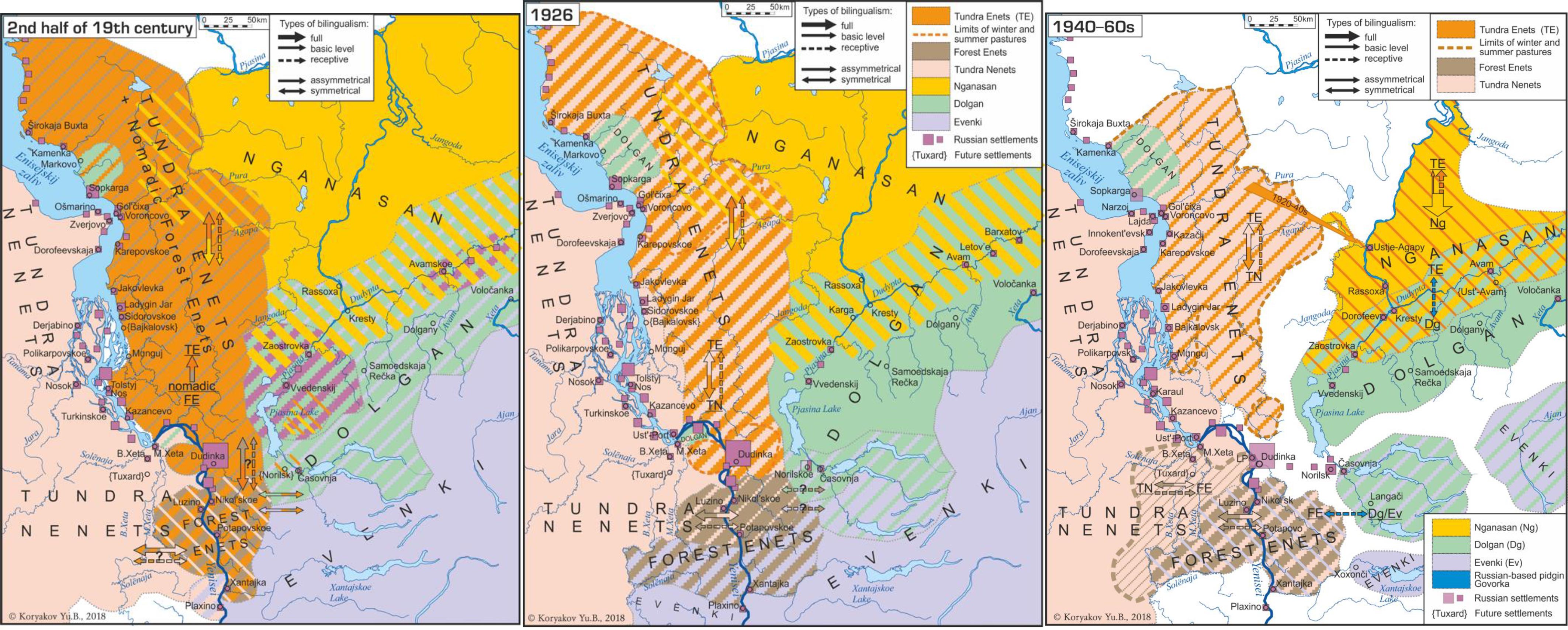
This pattern of traditional bilingualism or trilingualism, including widespread intermarriage customs, is common among traditionally allied Northern Siberian groups – related to shared subsistence economy rather than language family – and frequent language change is also well known from the historical period, including Samoyedic, Tungusic, and Mongolic groups (Khanina & Meyerhoff 2018, Khanina & Koryakov 2018).
1.2.5. Turkic, Mongolic & Tungusic
There is a growing corpus of appealing Proto-Turkic etymologies of Proto-Samoyed words, i.e. loanwords showing regular features of inner Samoyed development (Piispanen 2018). The approximately 30 reliable borrowings are thus comparable to the earlier Pre-PSmy.-PYuk. contacts, but with a reversed direction of influence, suggesting that Samoyeds had already become the ‘local’ culture under pressure from incoming nomadic elites:
- Horse-riding nomads:
- PSmy. *juntз ‘horse’ ← PTk. *junt ‘horse, mare’;
- PSmy. *ki̮r ‘gray hair (of animals), light, white’ ← OTk. qïr (CTk. *Kï̄r) ‘grey, grey-haired, color of horse’s coat’;
- PSmy. *kåŋ ‘lord’ ← PTk. *kān ‘lord’;
- PSmy. *kil’ ‘sable’ ← OTk. kil ‘sable’;
- Subsistence economy:
- PSmy. *jür ‘fat’ ← PTk. *ṻř ‘id’;
- PSmy. *kåptə̂- ‘to castrate’ ← OTk. qaptï ‘to grasp with teeth or hands’;
- PSmy. *pə̑jkз ‘dried fish’ ← PTk. *bālik ‘fish’;
- PSmy. *wekänä~*wekзrз ‘sturgeon’ ← PTk. *bEkre ‘kind of sturgeon’;
- Trade:
- PSmy. *yam ‘to wander with a tent caravan’ ← OTk. yam ‘a posting station’;
- PSmy. *päjmå ‘boots’ ← OTk. poyma ‘felt boots’~ CTk. *baλmak ‘kind of shoes’;
- PSmy. *jemńə̂- ‘to patch, to mend’ ← PTk. *jama- ‘to patch’;
- PSmy. *jikå- ‘sow, sharpen’ ← CTk. *(h)ẹ̄jke- ‘sow, sharpen’;
- Probably also from contacts related to commerce:
- PSmy. *jür ‘100’ ← PTk. *jṻř ‘id’;
- PSmy. *tettə̑ ‘four’ ← PTk. *dört ‘four’;
- PSmy. *ker- ‘to enter’ ← OTk. kir- ‘to enter’;
- PSmy. *jokə̑-~*jok- ‘to become lost’ ← PTk. *jōk-a-l- ‘to be lost, to disappear’;
- Kinship:
- PSmy. *inä ‘elder brother’ ← OTk. ini ‘younger brother’;
- PSmy. *jekə̑ ‘twin’ ← PTk. *(h)ẹjkiř ‘twins’;
- Nature:
- PSmy. *kil’ ‘winter’ ← OTk. qïl ‘winter’;
- PSmy. *pə̑t- ‘sink’ ← PTk. *bat- ‘sink, drown, set (about sun)’;
- PSmy. *ke̮pu ‘wasp’ ← CTk. *Kapuŋ ‘bumblebee’;
- PSmy. *puro ‘gray, wolfgray, wolf-gray dog’ ← OTk. boro ‘gray’;
- PSmy. *ta(ə)j ‘branch, ast’ ← CTk. *dal ‘branch, willow’;
NOTE. The loan of horse-related vocabulary from Turkic is common in forest-steppe and southern taiga groups like Ob-Ugric, including Yeniseian, cf. Ket qo:n ‘horse’ ← PTk. *qulun ‘foal’.
Based on the many known cases in language contact-induced change of correlative [language A] superstrate/adstrate (lexical) ↔ [language B] substrate (morphophonosyntactical) influences, it would be conceivable that Turkic showed a strong correlative Samoyedic substrate. Interestingly, some of the often-cited typological similarities of Uralic and Micro-Altaic, like their agglutinative nature or vowel harmony, might have arisen late and spread through intense areal contacts from west to east, with an ultimate Uralic connection finding further support in population genomics of Altaic-speaking populations (see below Proto-Turkic Homeland).
There is a later layer of Mongolic borrowings into Samoyed dialects, reflecting a common fauna in the Altai-Sayan region (Piispanen 2019):
- PMng. *kerije ‘crow, raven’ → Written Mongolian kerije(n) → Selkup kerja ‘raven’;
- PMng. *kürene ‘ferret, weasel’ → Written Mongolian kürene → Selkup kury ‘ermine’;
- PMng. *sïnkor ‘falcon’ → Written Mongolian singqur → Selkup seŋkjata ‘hawk’;
Similarly, some Proto-Tungusic borrowings have been proposed, although their irregularities make them unconvincing (Janhunen p.c. in Saarikivi 2020: 49). Dubious examples of late dialectal borrowings include (Piispanen 2019):
- PTng. *ābu- ‘a kind of duck’ → Nenets ńabu ‘duck’, Yurats njawétjä ‘duck’, phonologically difficult to accept.
- PTng. *kukti ‘cuckoo’ (→ pre-Evenki) → Proto-North Samoyed *kukti ‘cuckoo’ → Nenets xutij; Nganasan kotï. The other direction of borrowing is possible.
- PTng. *kūku (~ *xūku) ‘swan’→ Nenets xoxorej, Yurats kugórre ‘swan’. No exact correspondence with Samoyedic forms, and a PTk. *Kugu ‘swan’ also exists.
- PTng. *pige ~ *piage → Pre-Ewenki *piɣen → Kamass phigije , possibly more attractive as inherited from PU *päke ‘a kind of bird of prey’.
- PTng. *kāŋgu → Nganasan kaŋgü’’o , difficult to identify a donor language.
Later Samoyed varieties, most notably Sayan Samoyed, show evidence of intense contact with modern Turkic, Mongolic, and Yeniseian (Ket, cf. Joki 1952), with some Southern Samoyed groups like the Koibal, Mator, Karagass, Soyots, the Taigi-Samoyeds, and most recently Khakass – being recently linguistically Turkicized (Helimski 1996).
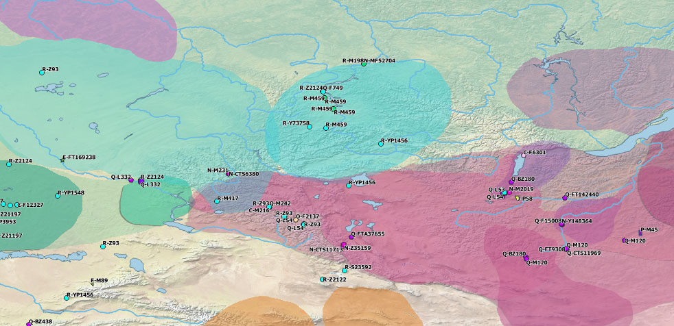
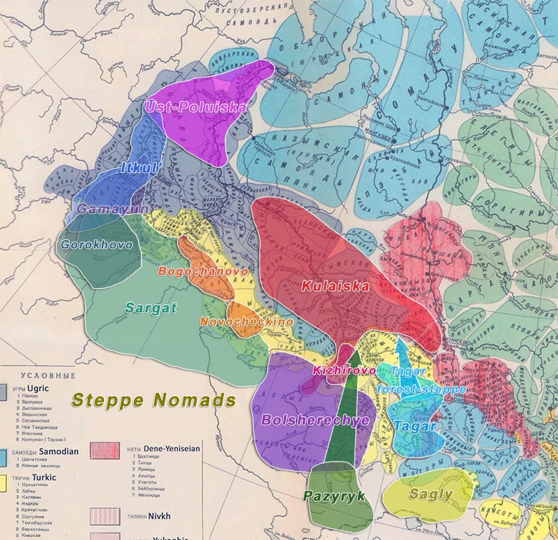
1.3. Hydronyms & ethnonyms
Samoyed toponymy is not well studied (except perhaps for Selkup areas), but there are more than 50 traditionally described non-Turkic names of water bodies considered of “Ugric Samoyedic” origin in Khakassia and neighbouring regions of Tuva, Kemerovo, and the Altai (Kyzlasov 1959: 73). Despite the general criticism by Dul’zon (1950, 1959, 1964), who deemed it best to try to etymologize non-Turkic names as Yeniseian first, there remains a considerable number of them with Samoyedic formants in -ba (-be), and with “Ugric” formants in -as, pointing to this South Siberian area in particular as an ancient East Uralic hotspot (cf. Kaksin 2018).
The Iranian-speaking area in contact with both Samoyed and Turkic is probably to be identified at least with formants in -lap, -lep, -rap, -rep, -rop (or in -man, -dan/-djan in the Upper Ob (cf. Kaksin 2019), among many others shared across Siberia which are difficult to etymologize as from a single language group (Maloletko 2005 – IV). Formants in -buj appear mainly in the Angara region (together with those in -chaga) and in the Circum-Arctic (mainly Upper Ob – Upper Yenisei) area, suggesting a connection with the Sixirtia that Samoyeds replaced on their expansion north (Maloletko 2005 – V).
The Proto-Samoyedic reconstruct for the Yenisei River, *jentəsi(-), was likely borrowed into Tungusic *jense(-gii), whereas PTk. *kem and PYen. *quk are arguably later. Given the lack of proper etymology of the word (or its division and meaning of ending -si-, if interpreted as a compound), its origin probably lies in the non-Samoyedic substratal language(s) of the Minusinsk basin (Janhunen 2012).
In a similar manner, a notable Samoyed toponymic layer lies in the Sayan area, including behind those of Turkic origin, although this is mostly a preliminary impression based on Helimski’s (1999) listing of toponymic details from Mueller’s manuscript on his 1739-1740 travels from Krasnoyarsk to the Steppes.

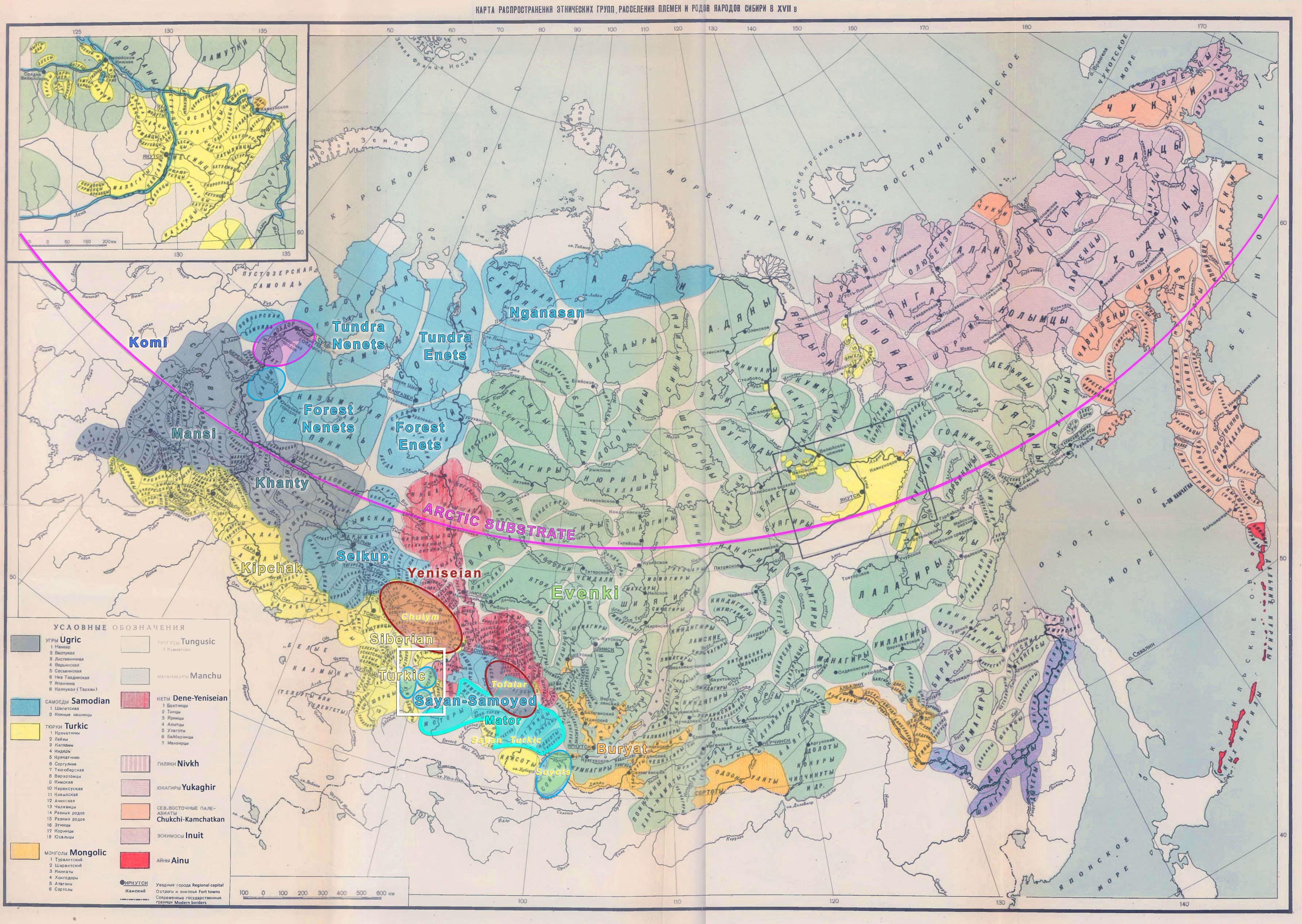
- Wider red area (more transparent) covers main Yeniseian hydronymy from Vajda (2020).
- Red elevated zone includes main Yeniseic hydronymy according to Maloletko (2000).
- Red border with shadowed rim: Core ancestral Cis-Baikal Common Yeniseian area according to Vajda (2019), between the Yenisei and Angara rivers.
- In red, sure Yeniseic hydronyms (with the basin of rivers or tributaries painted over in red, whenever possible). Dubious locations are marked with initial interrogation mark.
- In purple, likely Yeniseic formants without clear Yeniseian etymology.
- In magenta (with elevated painting over the water body), river or lake names of Yeniseic ethnonymic origin in gat/get, kat/ket.
- More questionable Yeniseic formants:
- In blue, names in ur.
- In brown, names in kul potentially spread by non-Yeniseic peoples.
- In orange, names in šet potentially spread by non-Yeniseic peoples.
- In fuchsia, formants in si/ši potentially related to Yeniseic, or to a preexisting Palaeo-Siberian substrate.
- In dark orange, possible Yeniseic water body formants (Blažek 2015).
- In pink, likely Sikhirtya (Sixirtja) hydronyms in -čaga, -bej.
- Within [brackets], ethnonyms based on foreign words (color on the outside represents linguistic group using it, font color represents original language group).
- In black, distribution of a common “Palaeo-Eurasiatic” hydronymic formant, kam-/kem-.
- In green, formants of Iranian origin.
- In cyan, formants of Samoyed origin.
- In yellow, hydronyms of Turkic origin and Turkic formants (see below Proto-Turkic Homeland).
For example, the alternative term for Lake Khövsgöl (← Turkic *kök+sub+köl ‘blue water lake’), Kosogol ← *ka(a)sa+köl is assumed by Eriksson & Janhunen (2015) to contain the ancestral local name in its first component, derived from PSmy. *kaəsa ‘man, human being’ ← *kaə- ‘die’ (← ‘mortal’), a word also borrowed into the Turkic ethnonym *kaac. Compare Tofa† tribal names Karagas ← *kara+kaash ‘Black Kaash’ and sarïg+kaash ‘Yellow kaash’, and among the Kamas ← Turkic *kam+kaash-ï ‘Shamanic Kaash’.
†The Tofa have a complex ethnogenesis, assumed to have been originally Yeniseic speakers that shifted to Samoyedic, and more recently to Turkic (see above).The nearby Egiin Gol River – originally Iga – also derives from a Pre-Turkic name, possibly connected to PSmy. *yəka ‘river’ (Janhunen 2012). Janhunen also hypothesizes that the same component might lie behind the -ga(-ge) of the Selenga River, where Selen- seems to be the first component, based on the also ancient attestation of alternative name Selimba.
Further, the second part of the Selkup ethnonym śȫśə k͔um (Upper Ob and Ket dialects) can be associated with the Yeniseic name of the river Ket (hence ‘people of the Ket’), like Yugh name Georg F. Miller recorded for the Pumpokol people (who inhabited the upper Ket). This name would have been thus borrowed by expanding Selkup groups from the indigenous Yeniseic speakers close to the Chulym River (Urmanchieva 2020), which is also supported by the strong Yeniseic substrate of Chulym(-Turkic).
It is quite clear that macrotoponyms of the Nenets area are of substrate origin from extinct languages. In the Lower Yenisei, despite the traditional accounts of Yeniseic languages reaching later than Samoyedic, local Samoyeds display ethnonyms derived from names etymologizeable as Yeniseic, suggesting that the place and river names they encountered during their northward migration were Yeniseic. For example, Yuraki, the name and self-name of the East (Taymyr) Nenets – previously referring to a separate Samoyedic ethnolinguistic group – probably derives from Proto-Ket *d’ər’ɛŋ, with the same meaning that passed through Selkup into Evenki ďuk- used to refer to Yughs. Similarly, ethnonyms and hydronyms from Ket through Selkup like zemshaki, imbaki ← Imbak river (Gusev 2020).
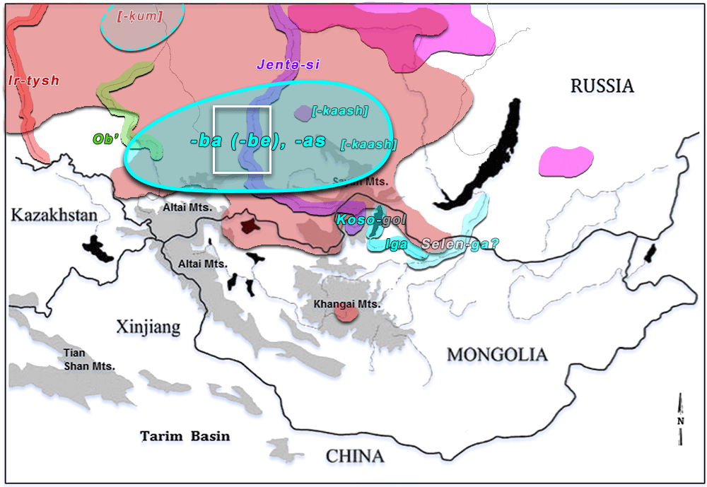
Map of the Altai-Sayan region including names mentioned in the text. Image modified from the blank map in Giosan et al. (2012) to include colored labels and areas: - Cyan: Samoyedic formants:
- Circled in solid line: approximate core area of formants in -ba (-be), and “Ugric” -as in Khakassia (and adjoining regions of Tuva, Kemerovo, and the Altai).
- Circled in dashed line: well-studied Selkup area of hydronyms etymologizeable as Samoyedic.
- [Within brackets]: Turkic ethnonyms of Samoyed origin.
- Pink: Yukaghiric formants (see above).
- Red: Yeniseic formants (Read more on Yeniseian hydronymy).
- Red area: Yeniseic hydronymy.
- [Within brackets]: Samoyed ethnonyms of Yeniseic origin.
- Purple, likely Yeniseic formants without clear Yeniseian etymology (through PSmy. *jentəsi).
- Green: Iranic formants (including the Ob’, through Russian).
- Within white rectangle: approximate location of the Minusinsk Basin.
1.4. Palaeolinguistics
In terms of reconstructible lexicon, Proto-Samoyed shows words for fir, larch, Siberian pine, as well as Siberian roe deer and flying squirrel, which taken together suggest a fairly southern location of the homeland within Siberia (Saarikivi 2020: 52). Of interest is the borrowing of a Turkic word for ‘horse’, a term of especial relevance for steppe-related populations (see below).
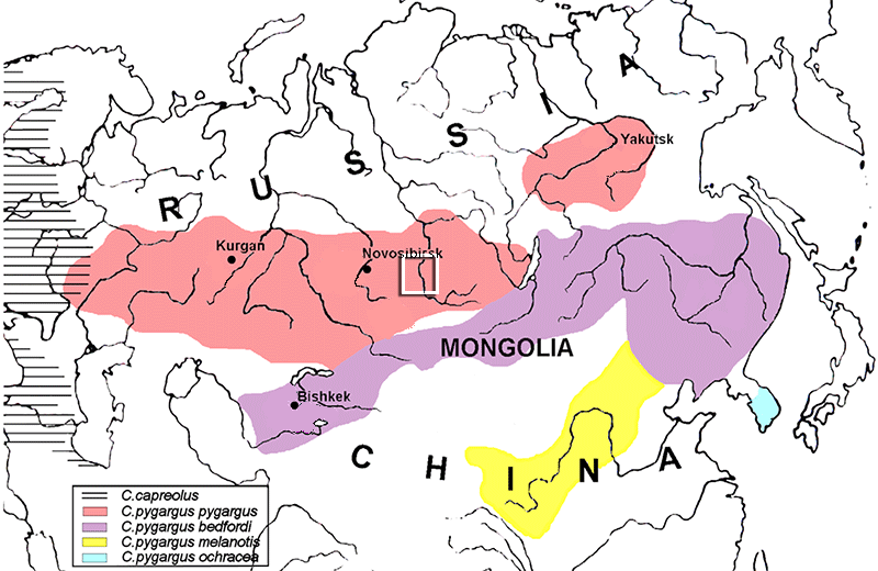
Modern distribution map of the Siberian and European roe deer. Within white rectangle: approximate location of the Minusinsk Basin. Image modified from Vorobieva et al. PNAS (2011). 3. Archaeology and population genomics
3.1. Western Siberia & the Minusinsk Basin
Based on the likely southern linguistic area of Proto-Samoyedic, Janhunen (2009: 72) places its homeland in the Minusinsk basin of the Upper Yenisei, splitting “perhaps slightly more than 2000 years ago” (Janhunen 2009: 63). He proposes that the Iron Age Tagar culture must have represented the Proto-Samoyed homeland (Janhunen 2009: 72). Based on the large archaeological continuity of Tagar materials and traditions with the preceding Late Bronze Age Karasuk culture, Parpola (2012: 294) estimates that Pre-Proto-Samoyeds stemmed from a large group of East Uralic-speaking peoples that spread with the Cherkaskul culture, which is further supported by the development of Ugric peoples in the Andronoid horizon (see above Ob-Ugric Homeland).
Helimski claims that from all Samoyed groups, the southern Selkups seem to have been residing the longest in the same area. Taking together the Samoyed hydronymy described from the southern Selkup territory to the Altai-Sayan area, as well as the proposed contact layers – (1) Pre-PSmy. ← Yeniseic, (2a) Pre-PSmy. → Pre-PToch., (2b) Pre-PSmy. → Pre-PYuk., (3a) PSmy. ← MIr. and (3b) PSmy. ← PTk. – there must have been large continuity of the core Samoyed-speaking area from pre- to proto-language stages in a fairly southern region, most likely around the Minusinsk Basin (cf. Helimski 2004: 120; Peyrot 2019; Saarikivi 2020; etc.).
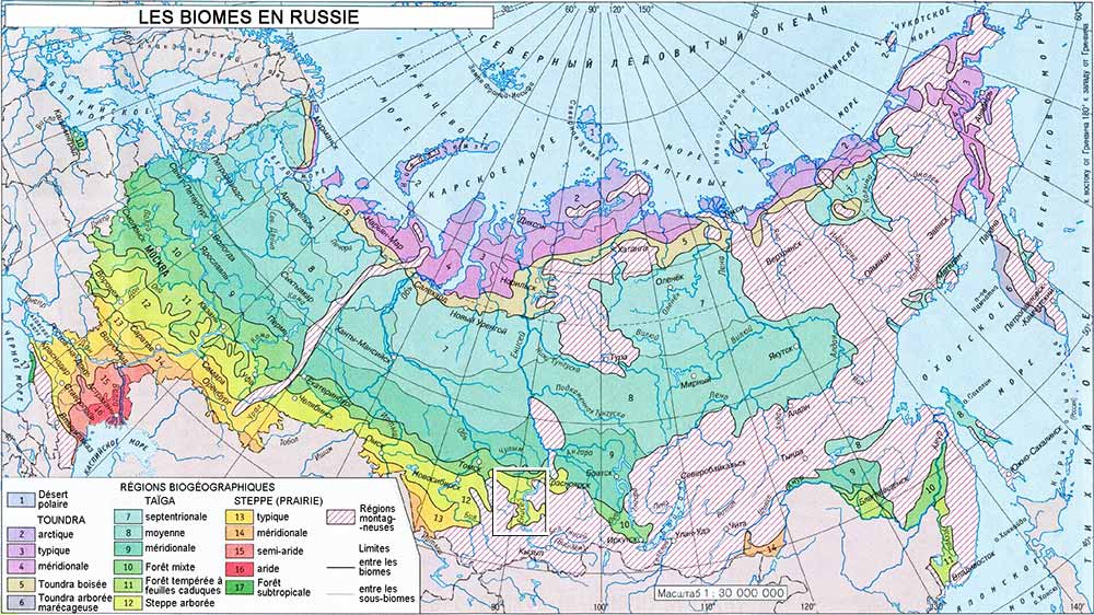
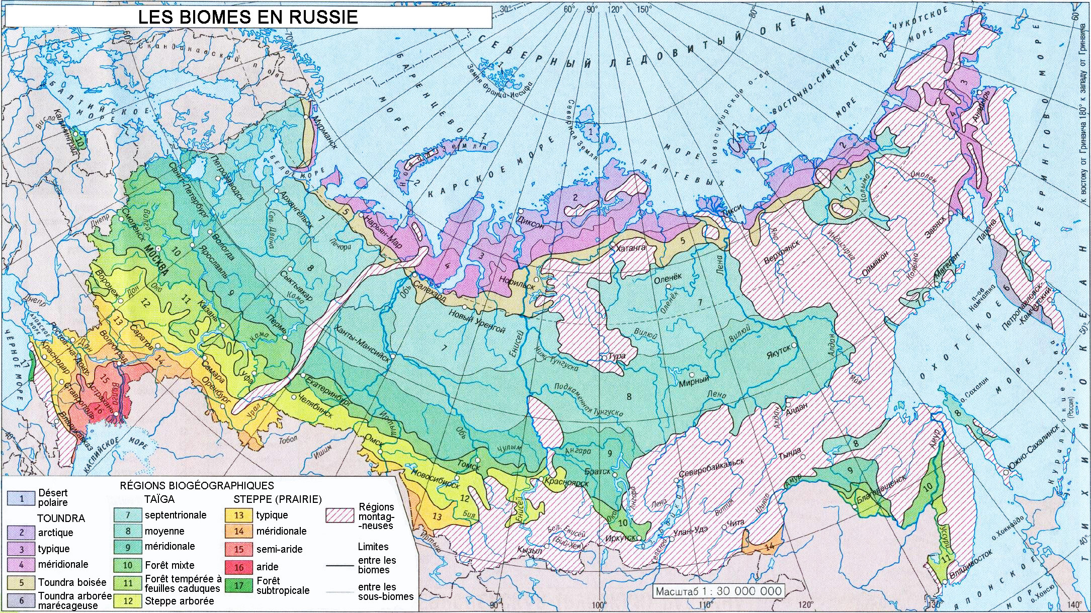
Vegetation in Russia. Within white rectangle: approximate location of the Minusinsk Basin. See full image. Image from Wikipedia, ultimately based on Ogureeva (1999). The following is a description of the area by Sophie Legrand (2006):
The Minusinsk Basin includes the middle valley of the Yenisei River and the upper valley of the river Chulym. It is surrounded on three sides by wide belts of high mountains – the Kuznetsky Alatau and the Abakan range to the west, the western Sayan to the south and the eastern Sayan to the east. The mountains are covered with dense forest, but the basin itself is steppe land. In the north-west corner of the basin is the ‘Tom-Chulym corridor’, a belt of wooded steppe that in ancient times linked the territory of groups of the Minusinsk area and those of the Altay and Kazakhstan. The Minusinsk groups could communicate with the rest of the world only by traversing those few difficult mountain passes. They were thus relatively isolated even from their nearest neighbours (Gryaznov 1969: 11).
The Bronze Age of the area divides into two main cultural phases: the Andronovo culture that characterised the valley from the seventeenth century BCE, and the Karasuk culture that succeeded it in the fourteenth century BCE. Geochemical analyses on deposits from Kutudjekovo Lake in the Minusinsk Basin revealed climatic changes between the Andronovo and the Karasuk periods (Kulkova 2003: 255-74). In the Andronovo period, the climate was semi-arid and slightly cool. From the beginning of the Karasuk period and later, the climate became more humid and cooler. Under arid climatic conditions the vegetation reacts quite sensitively to humidity, so the vegetation density increases as the humidity increases. This was the case in the Minusinsk Basin.
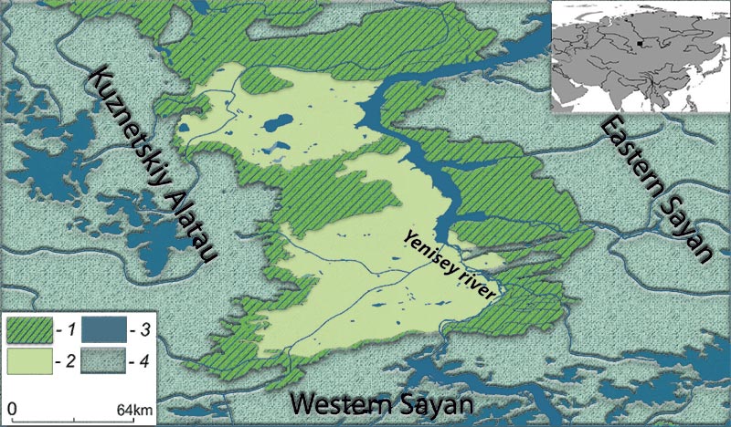
Geographical position of the Minusinsk intermountain basin (small figure) and distribution of altitudinal vegetation belts in this region (1 – forest-steppe, 2 – steppe, 3 – alpine, 4 – forest). Image modified from Ermakov, Polyakova & Didukh (2014). 3.2. Cherkaskul Middle Bronze Age
N. L. Chlenova, who published a detailed study of Cherkaskul pottery in 1981, plotted Cherkaskul monuments in her maps (1981 and 1984) not only in Bashkiria and Trans-Urals, but also in thick concentrations on the Upper Irtysh, Upper Ob and Upper Yenissei. Further west, further groups of Cherkashkul monuments appear along with Fëdorovo monuments (cf. Salnikov 1967; Khalikov 1969: 240–328; Chernykh 1992: 215).
As Parpola (2012: 292) notices, her conclusions have been manipulated and called into question. For example, her 1984 map (see below) has been reproduced in Koryakova & Epimakhov (2007: 113 fig. 3.1), but the label “Cherkaskul’” is replaced with “Cherkaskul’-Fëdorovo”. In the texts below, I refer to “Andronovo” in general as the MBA period of Cherkaskul materials – which developed in areas closely related to the Seima-Turbino phenomenon – and not to the Andronovo horizon proper.
NOTE. For a recent discussion of the history of research and the complexities of the “Andronovo cultural-historical community” and the lack of scientific consensus on the steppe (Sintashta-Petrovka, Alakul, Sargari) vs. forest-steppe (Fëdorovka, Cherkaskul, Mezhovska) division, see e.g. the recent open source Grigoriev (2020).
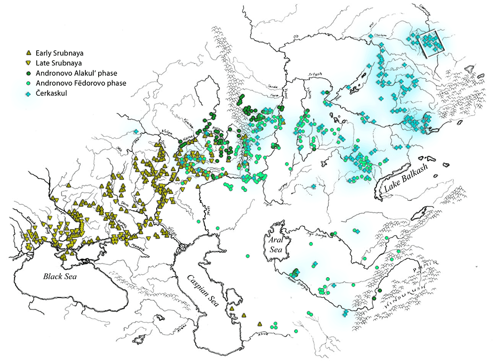
Distribution of Srubnaya (Timber Grave, early and late), Andronovo (Alakul’ and Fëdorovo variants) and Cherkaskul monuments. After Parpola 1994: 146, fi g. 8.15, based on the work of N. L. Chlenova (1984: map facing page 100). Image modified from Parpola (2012), to include colored symbols, as well as colored shadow for Cherkaskul sites. Within white rectangle: approximate location of the Minusinsk Basin. Only six settlements of this period have been investigated. At least in one of them, walled structures are interpreted as pens for livestock. Among domesticated animals, those of cattle were the most numerous, followed by sheep and horses in small quantities (Legrand 2006).
Cemeteries are located near lakes and rivers, mostly on the riverbanks of the Yenisei, in the south-west and centre of the Middle Yenisei region, with each cemetery including ca. 10-60 tombs. Burials consist of an enclosure, with variations: (1) circular ones or (2) rectangular ones with (a) upright slabs or (b) bedded slabs. The largest funerary structures – given the labor and energy expenditure necessary to build them – are those of high status persons, whereas the smallest ones contain infants or sub-adults (Legrand 2006).
Graves are rectangular, built in the center of the enclosures, sometimes lined with stout logs. The vast majority contain inhumations, most of them with the dead laid on their left side and in foetal position. Graves did not display much furnishing, except for pottery vessels (at least one) and occasionally some small bronze artefacts (Legrand 2006).
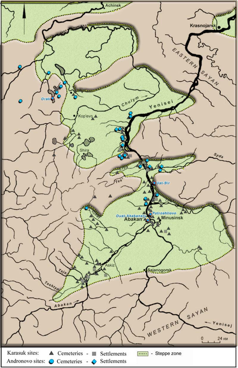
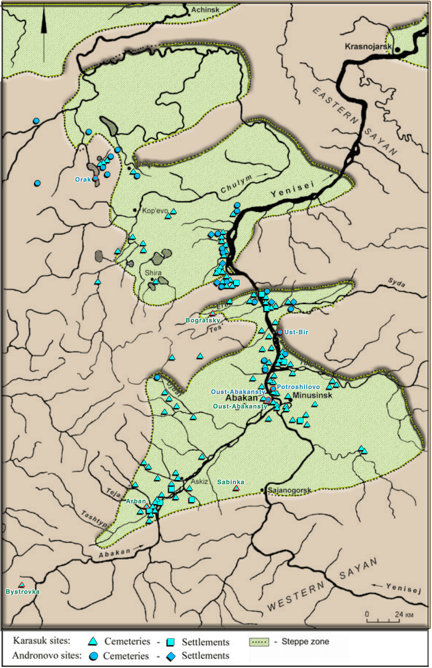
The Minusinsk valley, showing the location of excavated sites of the Middle Bronze Age Andronovo culture. Image modified from Legrand (2006), including colors for terrain and symbols. Locations with sampled ancient DNA have a red border and are labelled. See full map with all Andronovo-Karasuk sites. Sampled Cherkaskul individuals from Narasimhan Narasimhan, Patterson et al. Science (2019) include the following:
1. The excavation of the Orak burial place (ca. 1650 BC) in the north-western area is not well recorded, and the site contains burials attributed to the Fëdorovo type of the Andronovo complex and some to the Karasuk culture. The cemetery consisted of several oval kurgans, with square stone enclosures built on the mounds, and enclosures touching each other forming a complex network:
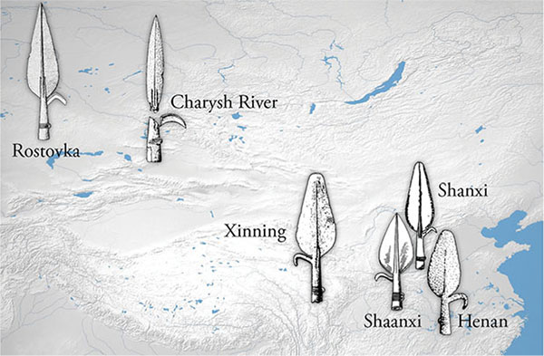
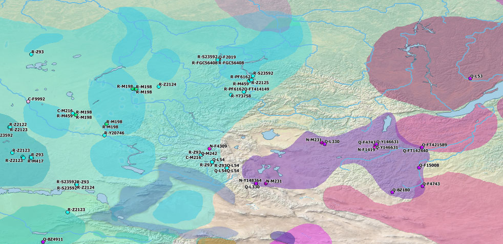
- Two basal R1a-S23592, one of them 2nd-3rd degree relative of the son in Family A (3 members). This subclade is found spreading early with Fëdorovo-Cherkaskul sites through Russia and Kazakhstan, following closely the trail of Seima-Turbino materials (see map of ancient R-S23592 and timeline slideshow).
- Four basal R1a-FGC56408 immediately downstream from R-S23592, two of them father-son in Family A. The father, I6718, is the only radiocarbon dated individual, ca. 1615-1466 calBCE. The same haplogroup is found later among Bronze Age populations from the Altai-TianShan area, and later among Scytho-Siberians and other “Scythian” groups, Xiongnu, and more recently among medieval steppe nomads (see map of ancient R-FGC56408 and timeline slideshow).
- The outlier I6717 (ca. 1440 BC) with Baikal-related ancestry shows a basal hg. Q1b-F2019, within a rare branch Q1b-L932 (TMRCA ca. 5900 BC) that might have been widespread through Central Asia before the expansion of Andronovo and Andronovoid groups, judging by their appearance as outliers with different ancestry profiles, from Steppe Maykop to Sintashta-WSHG, Andronovo-BMAC, and (integrated in terms of admixture) in Tagar (see map of ancient Q-L932 and timeline slideshow).
2. The Ust-Bir IV cemetery is located on the right shore of the Birya River mouth. It consists of 28 graves (cists and log house tombs), with one grave showing an oval pit faced with vertical logs, and one grave is covered by Okunevo stele. Remains of cremations have also been found. For the most part there is a single individual in each grave, but in some cases, there are two individuals in a grave.
- The only male from the three sampled individuals shows hg. R1a-S23592.
3. The Potroshilovo II cemetery is located at the mouth of the Tuba River, 3 to 3.5 km southeast from the former settlement of Potroshilovo. The cemetery consists of 11 enclosures and 23 graves. Most graves contained a single skeleton. Individuals were laid on the left or right side with heads turned to the southwest, and some were cremated. Grave goods consisted of pottery, awls, bone comb, bronze beads, rings, remains of leather, wood (possibly a vessel lid) and textile, cattle, sheep and roe-deer bones.
- Out of the three males, I1856 (ca. 1590 BC) shows R1a-S23592(xYP1359,xYP1456,xY73758), so either basal R-S23592 or R-FGC56408 (or downstream), whereas the other two could not be further reliably determined below R1a-PF6162/Z645.
4. A chief kurgan from Oust-Abakansty was also sampled by Keyser et al. (2009), and its STRs compared recently (Keyser et al. 2020) to other ancient samples suggest that it belonged to the same upstream R1a-Z2125 branch.
The few remaining (Pre-)PIIr. loans suggest that Samoyed was in contact with the Indo-Iranian branch during the Disintegrating Proto-Uralic period, supporting the traditional origin of Eastern Uralic around the forests and forest-steppes of Eastern Europe, and the isolation of the branch to the east of the Urals. At the same time as Sintashta-Potapovka entered in contact with BMAC-related agriculturalists – when Proto-Indo-Iranian acquired its own Asian Substrate distinct from the European one – Abashevo-related peoples probably migrated to the east of the Urals through the forest-steppes, at a time when agriculture was not yet developed in the region. That would justify the loss of most of the Agricultural Substrate reconstructible from Uralic branches to the west of the Urals.
The paradigmatic “Eastern” Cherkaskul-related migration shows a clear star-like phylogeny of R1a-S23592 lineages (coinciding formation and TMRCA ca. 2400 BC, including immediately downstream subclades) roughly coeval with the assumed expansion of Abashevo. Y-DNA bottlenecks under R-Z2124 can be seen – as expected – to progress differently in both cultural contexts: the Indo-Iranian-speaking Srubnaya-Andronovo horizon through the steppes to the south, and the East Uralic-speaking Andronovo-like cultural horizon through the forest-steppes and forests to the north, following Seima-Turbino materials.
Y-DNA from MBA cultures of Western and Southern Siberia, including likely East Uralic-speaking Cherkaskul groups to the north (blue-cyan), and likely Iranian-speaking Fëdorovo groups to the south (green), with Baikal-related groups Glazkovo (magenta) and Munkh-Khairkan (violet) to the east. See full maps. 3.3. Karasuk Late Bronze Age
There is evidence from seven settlements of the Karasuk period with large, rectangular wattle-and-daub semi-subterranean dwellings. Buildings with sophisticated architecture suggest permanent settlement, as opposed to the previous nomadic or seasonal occupation. Remains from domestic animals include sheep-goats (61%), cattle (23%), and horses (11%). In Karasuk settlements such as at Kamennyj Log and Torgazhak, bone cheek-pieces with three holes – a type found on early Scythian models – are found, and a rider on a horse carved on a slab-stone from an enclosure in the Karasuk cemetery of Krest-Khaja suggests that the riding of horses was widespread (Legrand 2006).
The distribution of cemeteries is much more widespread than in the previous period, spanning the entire Middle Yenisei region. Unlike Andronovo funerary sites, Karasuk cemeteries are vast clusters from several hundred to over a thousand tombs situated on the edges of rivers and lakes, with smaller cemeteries (5-15 tombs) also found at the foot of the mountains. The location of enclosures is generally coincident with the previous Andronovo sites, and separated from those of preceding cultures (Legrand 2006).
Burials show a stone-walled enclosure with the same four types of the Andronovo period but in different proportion, with rectangular upright-slab now dominating. A new oval-shaped type is introduced. Some features suggest a more complex set of rules followed for burials, with a correlation of the type of walling and the ground plan of the enclosure, and geographically and chronologically sensitive rules: rectangular enclosures dominate in most areas, but square shapes are prevalent in western and south-eastern areas (increasing use from north to south), whereas circular enclosures – prevalent in Andronovo – appear more often in north-western and western areas, decreasing in the opposite direction (Legrand 2006).
This suggests that the Andronovo tradition remained stronger in peripheral areas isolated from innovative ‘population centers’ concentrated on the banks of the Yenisei in the mid-section of the Minusinsk Basin. Karasuk cemeteries are organized in clusters of 2-20 enclosures, while isolated burials (frequent in the previous period) are less common and show frequently Andronovo-like circular enclosures. Funerary structures continue to contain usually a single burial, but multiple burials are found more often. This change to small family cemeteries suggests a modification of the social structure (Legrand 2006).

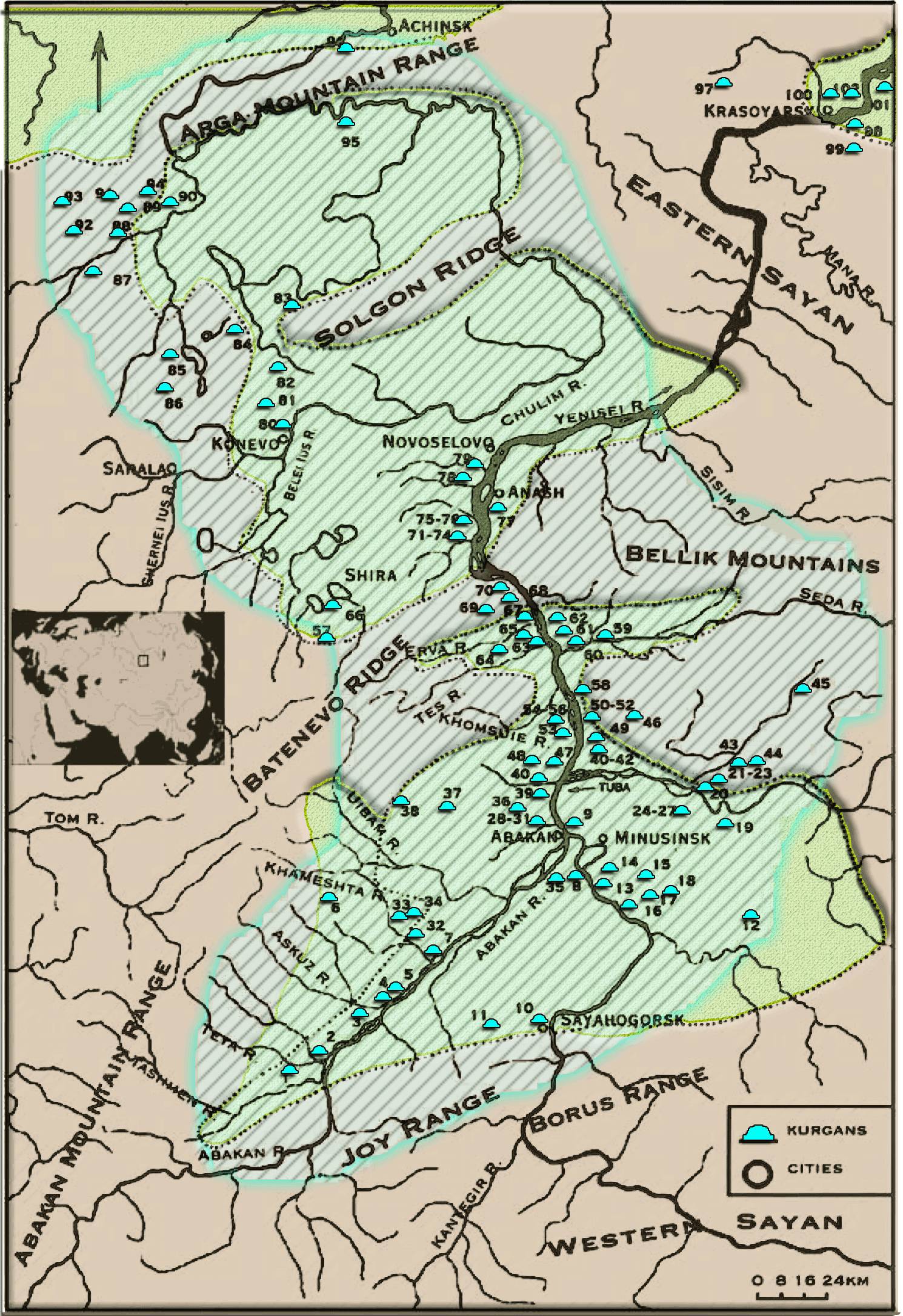
The Minusinsk valley, showing the location of excavated sites of the Late Bronze Age Karasuk culture. Image modified from Legrand (2006), including colors for terrain and symbols. Locations with sampled ancient DNA have a red border and are labelled. See full map with all Andronovo-Karasuk sites. Cists built as a pit faced with stone slabs (and covered with one or more stone slabs) remain the most widespread type in all areas of the Minusinsk Basin, and different types show geographical patterns supporting the described innovative center vs. traditional periphery. The position of the head was reversed in the Karasuk period, to orient it to the north-east, east or east-north, the feet following the position of the setting sun throughout the year. The transition of Andronovo to Karasuk pottery is smooth, with continuation in the early phase succeeded by new features especially prominent in ‘population centers’ (Legrand 2006).
The more elaborate attention accorded to children and complex architecture of burial enclosures evidence a hierarchical order based on a patriarchal system. Further, the increase in the number of sites suggests an increase in population, so that by the end of the Karasuk period the population had multiplied by a factor of ten (Legrand 2006).

Left: Distribution of Karasuk and Karasuk-type bronze Knives (quoted in Sophie 2004b, p. 152) Karasuk metallurgy: Technological development and regional influence. In M. L. Katheryn (Ed.), Metallurgy in Anceint Eastern Eurasia from the Urals to the Yellow River (p. 152)). Right: Phase I of the Northern Zone of China-Mongolian Plateau Metallurgical Province. Images modified from Yang, Shao & Pan (2020: 203-204). During the Karasuk period, copper and bronze metallurgy developed to an unprecedented degree, with numerous copper alloy objects found in cemeteries and settlements, including also mines and workshops. The role of metallurgy was prominent in the Karasuk economy and it exploited numerous and abundant local sources in the Minusinsk Basin. Progress in metal casting (use of moulds of pottery or metal, and no longer of stone) may have promoted mass production and thus expanded the output and the capacity for off-site and long-distance distribution (Legrand 2004: 144). The high increase in population may also have stimulated the metallurgical industry. In addition, increased mobility must have been a decisive factor in its widespread distribution (Legrand 2006).
Archaeological findings show that the bronze remains of the Minusinsk Basin, the core distribution area of the Karasuk culture, are closely related to many cultures, especially those of the Shang and Zhou periods in China’s Northern Zone and the Central Plain. This “Karasuk Bronze” exhibits a high level of similarity in shape and design with their counterparts from the Northern Zone. The dating of artifacts suggests that the first route of transmission involved the prevalent notched cross-guard short swords from the Minusinsk Basin (after the 10th c. BC), found later during the Western Zhou period in the Northern Zone. On the other hand, swords with animal-shaped pommels – found through vast areas from the Northern Zone, Mongolia, Transbaikal, and Southern Siberia – show the earliest dates close to the Northern Zone (Chaodaogou site, Qinlong, and Ömnögovi aimag, Mongolia), probably attributed to the Shang period, as do swords and knives with bell-shaped pommels (Yang, Shao, & Pan 2020: 202-208)
The appearance of fine-decorated pottery and the socketed axe of the Karasuk type in the Cis-Baikal Ust-Belaya II burial ground was described as a foreign influence, rather than as the arrival of a new population, because the analysis of scarce bronze items – including socketed axes – shows their local production on the basis of native copper in copper sandstones of the Irkutsk region (Goryunova, Smotrova, 1981: 28; Sergeeva, 1981: 29). The finding of Andronovo-related outliers among Baikal-related groups (see below) might contradict this interpretation.
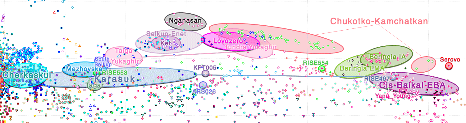
Caption of PC1-PC2 of ancient and modern Eurasian populations, marking clusters of groups relevant for the discussion. See full PCAs by period, including different visualizations of PC1, PC2, PC3, and PC4. Karasuk samples – most of them published in Allentoft et al. Nature (2015) – clearly show a recently forming cline of Cherkaskul-related peoples with Baikal EBA groups, clustering close to the Glazkovo outlier with Afanasievo-related ancestry, KPT005 (see above Proto-Yeniseian Homeland). They also cluster close to the slightly later Deer Stone-Khirigsuur Complex individuals from Khövsgöl (Jeong et al. PNAS 2018), where the Steppe MLBA-related outlier ARS026 (ca. 1000 BC) is found displaying an ‘archaic’ basal hg. R1a-Z2124(*/Z2125*) among a Q1b-rich community patrilineally related to Baikal EBA populations, also including an N1a-Tat sample.
The WSHG-ESHG ancestry shift among Karasuk samples related to the Andronovo-related ones seems to be closest to the earlier outlier from the region, I6717. On the other hand, a clear Karasuk outlier, RISE497 (ca. 1150 BCE), a female from Arban 1, shows an ancestry fully compatible with the Cis-Baikal BA cluster.
In terms of Y-DNA haplogroups:
- From Sabinka 2, sample RISE493 (ca. 1470 calBC) shows hg. Q1a-FT414149. The same subclade is found earlier in an Okunevo individual from Uybat V (see above Proto-Yeniseian Homeland), and later in a Sagly individual from Ulaangom. Sister clade Q1a-L715 is also found later close among Scytho-Siberian-related populations. The more distant cousin Q-F4705 is found in Central Asia and downstream Q-F4741 (TMRCA ca. 2700 BC) among the Shirenzigou (see map of ancient Q-L712 and timeline slideshow).
- Also from Sabinka 2, I3425 (ca. 1340 calBC) shows hg. R1a-PF6162/Z645, without relevant calls downstream.
- From Arban 1, sample RISE496 (ca. 1335 calBC), shows basal hg. R1a-Y73758, directly downstream from R1a-S23592 (see map of ancient R-Y73758 and timeline slideshow).
Y-DNA from LBA cultures of Western and Southern Siberia, including likely Pre-Proto-Samoyedic-speaking Karasuk culture around the Minusinsk Basin and (Ugric-speaking?) Irmen culture to the west, with likely Iranian-speaking Simple-Relief-Band Ware groups to the south (green), and Baikal-related groups (magenta) like DSKC, Slab Grave, or Tevsh. See full maps. The spread of Cherkaskul materials is therefore the most evident cultural vector to be associated with the expansion of Pre-Proto-Samoyed over Yeniseic-speaking areas. The evolution of a tighter Andronovo cluster into a wider Karasuk one, at the same time as the Andronovo-like population expanded under an evident R1a-Z93 bottleneck up to (at least) the Khövsgöl area, suggests that the new sedentary ‘population centers’ of the Minusinsk Basin represented an integration of locals into the new hierarchical society, with the whole community shifting to the Pre-Proto-Samoyedic language of the elites.
Contrary to the usual situation, where lineages of locals do not appear in the archaeological record (see e.g. the evolution of Iberia Bronze Age), there is further confirmation of this gradual admixture process in the early Andronovo Q1b outlier of Baikal-related ancestry, and in the later Q1a sample more or less integrated within the wide Karasuk cluster, both buried in the same cemeteries as the elites. The gradual absorption of the local population under incoming Abashevo-related migrants despite the widespread survival of Yeniseic hydronymy would support the simplistic hypothesis of Kirushin (1992, 2002), whereby the Elunino people moved northward under the pressure of incoming “Andronovo” colonists not later than the 18th century (see above Proto-Yeniseian Homeland).
The actual chronological and geographical location of the inferred substratal influence of Proto-Yeniseic (through Pre-Proto-Samoyedic?) on Pre-Proto-Tocharian is unknown, due to the likely long-lasting “pre-proto-language” stages of the latter and the widespread areas of the three language families in the Middle Bronze Age compared to their later proto-language stages. Nevertheless, the finding of R-S23592 samples around the Altai and Tian Shan Mountains during the Bronze Age, among groups already admixed with varied Baikal- and WSHG-related contributions and haplogroups of diverse origins, at the same time as Chemurchek evolved into cultures of stone burial constructions, offers the best theoretical framework for the proposed intense ethnolinguistic exchanges of South Siberia.
In fact, the survival of Afanasievo-related ancestry in an outlier close to Lake Baikal (see Yu et al. 2020) and in a Munkh-Khairkan individual (ca. 1750 BCE) from Khovd (see Jeong et al. 2020), including large continuity of their ancestry with the Eastern Tian Shan Iron Age Shirenzigou (see Wang et al. 2020), point to the survival of Pre-Proto-Tocharian-speaking Chemurchek-related populations in the Altai-Sayan/Tian Shan region, where strong archaeological ties are found between Karasuk and the Northern Zone in metallurgy. This supports the linguistic finds of intense Tocharian-Chinese interactions, as well as the appropriate prehistorical context for the exceptional borrowing of the word for ‘metal; money’ from Samoyed into Tocharian.
3.4. Tagar Iron Age
The significant increase in humidity and the slight temperature rise in the steppe that occurred about the 1st millennium BCE probably became widespread. This progressive change has been well traced from western Central Asia to Western Siberia (Levina 1996), and probably stimulated movement of some nomads across long distances. By the end of the 2nd millennium BC the natural conditions of the steppe-like valleys of the Sayan and Altai mountains in central Southern Siberia were most favourable for sheep breeding (Bokovenko 2006).
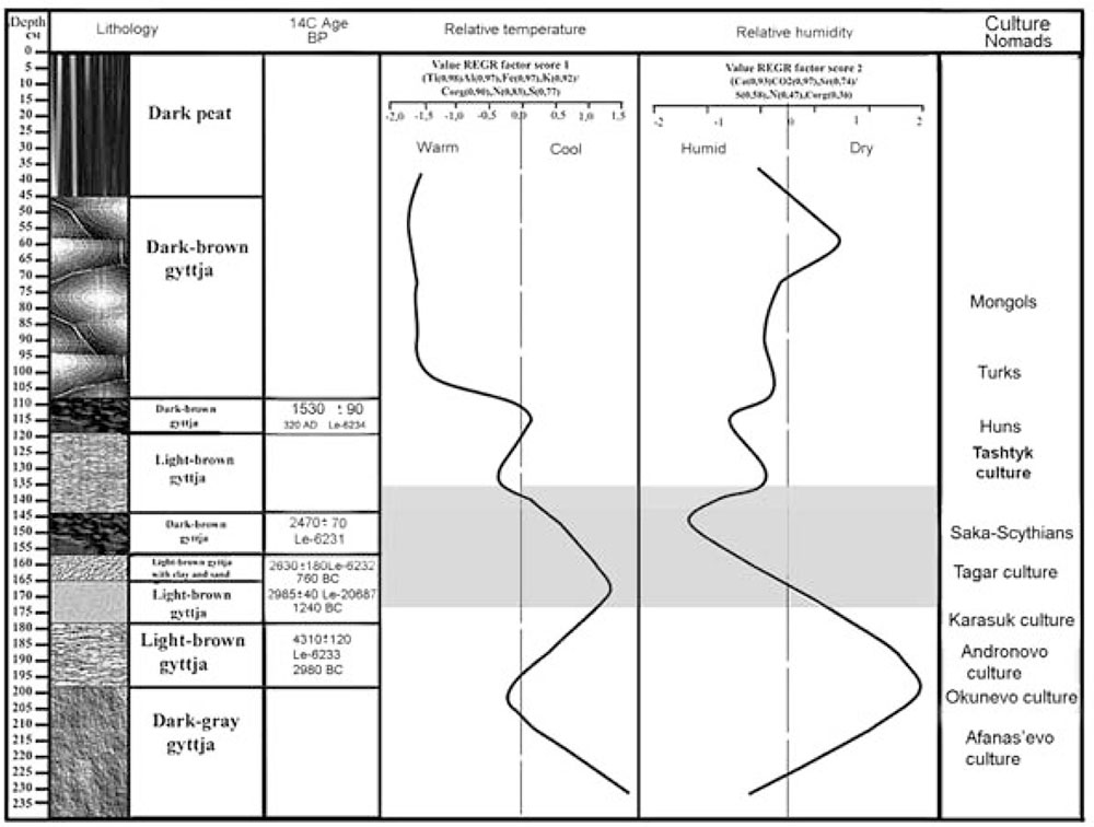
Palaeoclimate geochemical records. Sheep pasturing was limited territorially in the Minusinsk valley as compared to the Kazakh steppes, where people could migrate about 1000km with their cattle. Seasonal migrations in the Sayan and Altai mountain regions were mostly vertical. Just at the beginning of the 1st millennium BCE, there was significant progress in horse breeding – including new forms and more reliable types of bronze bridles – which became the basis for a society of horsemen (Bokovenko 2000). The increased resources and opportunities for growth coincided with social stratification, and the emergence of a structured system of authority (Bokovenko 2006).
In the post-Karasuk period during the Final Bronze Age (ca. 11th-10th centuries BC), simple pits (appearing previously only in peripheral Karasuk zones) became more common; the dead appeared in a stretched position, lying on their backs (as in the previous period), but the burial returned to the ‘traditional’ south-western or western orientations (Legrand 2006).
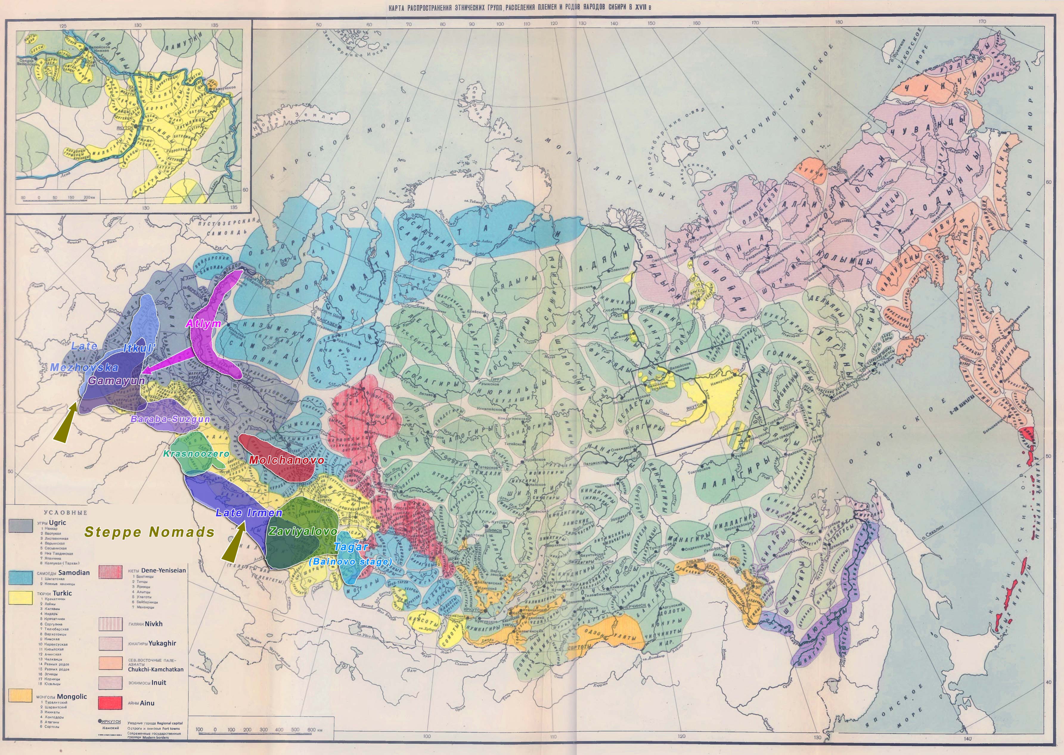
Transitional Late Bronze Age – Iron Age cultures (ca. 800-600 BC) of Siberia overlaid over AD 1600 ethnolinguistic map. See full image, or full image with Yeniseian substrate as background. The source is referenced in the first post of the series. The Tagar culture is divided into four cultural phases (Gryaznov 1986): Bainovo (end 10th-8th c. BC), Podgornovo (8th-6th c BC), Saragash (6st-3rd c. BC) and Tes’ (2nd-1st c. BC – AD 1st c.). In the Krasnoyarsk forest-steppes, the culture appears later and – due to its similar features – it is considered an expansion of Tagar peoples rather than an acculturation of the local one (Bobrov 2011). It is divided into three stages: Bol’shepichugin (6st-5st c. BC), Tisul’ (4st c. BC), Nazarovo (3rd c. BC), and post-Tagar Shestakovo (2nd-1st c. BC).
As in the previous period, the Tagar burial tradition consists of dead buried in square or rectangular enclosures made of vertically standing stone slabs, covered with a pyramidal burial mound. The enclosures and the graves they contained increased in size and depth over time, as did the number of bodies buried in each stone cist, with stone cists being replaced over time with timber frames. In the early period, the dead were buried in a supine position with their heads consistently oriented to the south-west, continuing the post-Karasuk period (Bokovenko 2006).
Social stratification is especially apparent in the Saragash period, where there is further elaboration of the burial ritual and construction of burial superstructures. Barrows of about 20m in height are located in the Salbyk Valley in the center of the Minusink basin and exemplify this trend, with the labor necessary to construct the Bolshoi Salbykskii Mound in particular suggesting an elite person, a chief of the confederation of Tagar tribes (Bokovenko 2006).
The Tes’ period continues the complexity of the burial rite, but there is considerable variety. Comparing tomb structure, grave furnishings and funerary rituals of the successive phases of the Tagar culture, there seems to be no abrupt changes in economic, domestic or social patterns suggestive of sudden displacements of large numbers of people, but the penetration of small groups coinciding with social changes suggested by the increasing size and complexity of burials cannot be excluded (Bokovenko 2006).
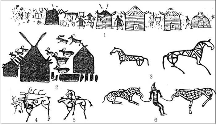
Iron Age cultures (ca. 600-200 BC) of Siberia overlaid over AD 1600 ethnolinguistic map. See full image, or full image with Yeniseian substrate as background. The source is referenced in the first post of the series. Tagar continues a highly developed bronze-casting industry stemming from old traditions, with the most common weapons being daggers, battle-axes and arrowheads. The total bridle system including the various strap connecting pieces, pendants, and cheek pieces continued to be refined during the whole Tagar period. The abundance and diversity of horse-harness items and the numerous petroglyphs illustrating horses are evidence of the great role that horse breeding played in the Tagar society (Bokovenko 2006).
In fact, petroglyphs of the Scythian period are numerous and of high aesthetic standards compared to the surrounding regions, with similar symbolic images reflecting a widespread “Sajano-Altay” religious system including shamanistic rituals similar to Pazyryk (Sorokin 1978; Kuzmin 1992; Bokovenko 1996). This strong religious and cultural connection to horse-breeding cultures strongly suggests an association with ‘foreign’ elites, vector of the Proto-Turkic influence during the development of Proto-Samoyed.
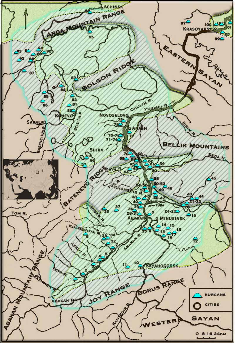
The Minusinsk valley showing the location of Iron Age sites (Tagar culture). Image modified from Bokovenko (2006). See full image. Bainovo period samples from Grishkin Log 1 (ca. 900 BCE) show a tight cluster roughly within the earlier wide Karasuk group, but possibly closer to the ‘southern’ steppe-related clines formed by Scythian groups:
- Q1b-F749, a subclade of a haplogroup found widespread through Central Asia map of ancient Q-L932 and timeline slideshow).
- Three R1a-Z94, at least two of them R1a-Z2124, with the best coverage one (the only radiocarbon dated, ca. 925-810 calBC) displaying a basal hg. R1a-Z2124/Z2125 (no call for Z2125). A similarly basal R1a-Z2124/Z2125 is also found in the earlier DSKC outlier from Khövsgöl (see map of ancient R-Z2125 and timeline slideshow).
Two sampled males from Afontova Gora, to the north-east of the Minusinsk Basin, show two fully different profiles:
- RISE554 (ca. 930 BC), of hg. N2-MF52704, shows a Baikal-related ancestry (see map of ancient N-MF52704 and timeline slideshow).
- RISE553 (ca. 870 BC), of hg. R1a-M198 (low coverage), shows a Karasuk-related ancestry more ‘northern’ than Tagar samples.
The cluster formed by the Grishkin Log 1 and RISE553 samples is remarkably ‘western’ compared to most other “Scythian” (and especially neighbouring “Scytho-Siberian”) groups, which supports genetic continuity in the Minusinsk Basin, at least in the early period, and at least in terms of admixture with the local population.
Y-DNA from Early Iron Age cultures of Western and Southern Siberia, including likely Uralic-speaking Tagar culture (Bainovo stage) in the Minusinsk Basin (blue-cyan), and likely Iranian- or Turkic-speaking Scytho-Siberian groups (green), with Baikal-related Slab-Grave (magenta) to the east. See full maps. All Tes’ period males sampled, from Oust-Abakabsty, Bogratsky, Chernogorsk, and Beysky, show (STR-based) hg. R1a.
The inferred direct relationship between groups of Central Asian horse-riding (forest-)steppe nomads suggests that the Saka and related western “Scythian” groups spoke the Middle Iranian languages that influenced Proto-Samoyed, whereas at least part of the eastern “Scytho-Siberian” populations (such as Pazyryk, Sagly or Berel) that were in close contact with Tagar spoke varieties of Proto-Turkic. The roughly equivalent guesstimates of 1st millennium BC for Proto-Samoyed and Proto-Turkic (see below Proto-Turkic Homeland) as well as the lack of Oghuric traits in Samoyed loanwords compared to Ob-Ugric suggest that the origin of Tagar elites is geographically different from those behind Tasmola or Sargat (see above Ob-Ugric Homeland).
Y-DNA from Late Iron Age cultures of Western and Southern Siberia, including likely Uralic-speaking (post-)Tagar culture, and Yeniseian/Turkic-speaking Xiongnu groups to the east (magenta). See full maps. 2.5. Ust-Mil, Ulakhan-Segelennyakh, Sugunnakh
West of the Lena, the large and long-lasting Ymyyakhtakh cultural horizon (ca. 2200-1300 BC) was succeeded by groups of mixed Cis-Baikal and autochtonous roots like Ulakhan-Segelennyakh, Ust-Mil, and Sugunnakh cultures (Alekseyev, Dyakonov, 2009; Dyakonov, 2009: 19), whose precise chronological sequence, specific cultural traits, and ultimate origin and demise are still not well defined.
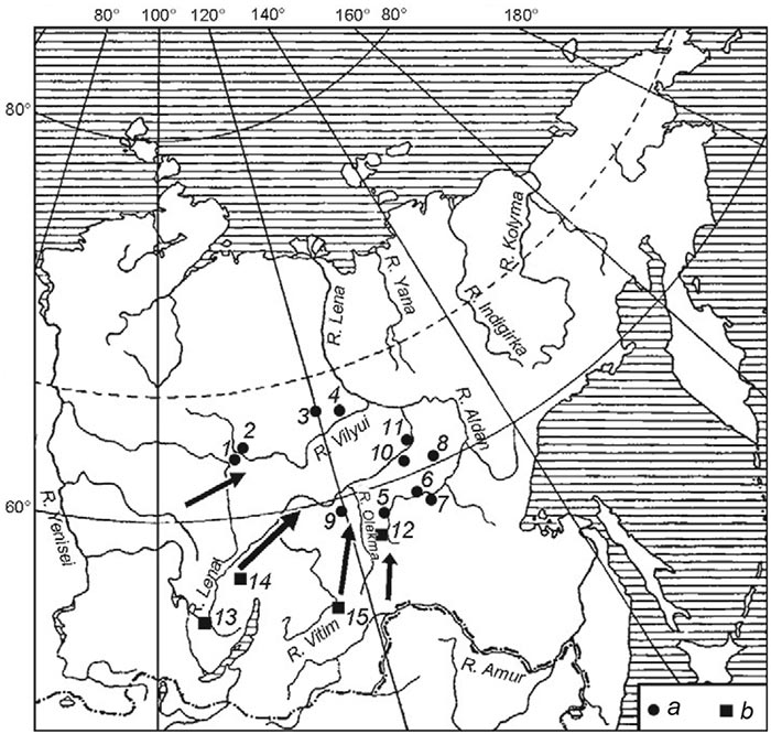
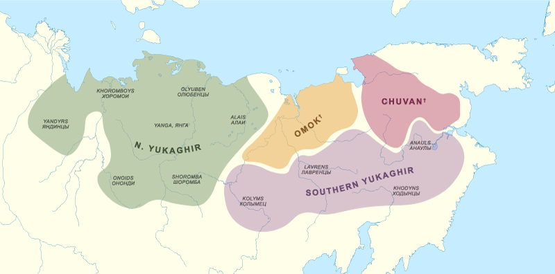
Map showing location of (a) sites belonging to the Ulakhan-egelennyakh culture (ca. 1900-1350 BC) (b) sites presumed to be associated with it. 1 – Ust-Chirkuo I; 2 – Ulakhan-Ediek I and II; 3 – Syangda; 4 – Khotu-Tuulaakh; 5 – Ust-Chuga II; 6 – Sumnaghin II; 7 – Ughino I; 8 – Tangha I; 9 – Ulakhan-Segelennyakh; 10 – Khongsuor; 11 – Nemyugyuntsy; 12 – Aldakai I; 13 – Ust- Chikaltui-1; 14 – Ust-Minya-1; 15 – Ust-Karenga-12, -14, and -16. Arrows show presumed migration routes of tribes ancestral to Ulakhan-Segelennyakh. Image modified from Dyakonov (2012). Yukaghir has all but died out in the 21st century. The surviving ethnic groups stemming from reindeer-herding Lower Kolyma (or Tundra) Yukaghirs, and the hunter-gatherer Upper Kolyma (or Taiga) Yukaghirs, are on the brink of full Russification. This likely mimics the process of previous acculturation events under the pressure from Evenki, and even under Koryak (like the 18th century assimilated Chuvantsy).
Since sampled Yukaghirs show Y-DNA haplogroups in common with Russians (R1a-M458, I1, I2a) and Koryaks (C2), apart from N1a (cf. Fedorova et al. 2013, Duggan et al. 2013, Ilumäe et al. 2016) it is very likely that (at least some) Evenki groups are the best representatives of the predominant Yakutia Late Bronze Age / Iron Age ancestry and Y-chromosome haplogroups. The widespread presence of (full-fledged) N1a-M2019 among modern populations from Yakutia (see maps of modern distribution of hg. N1a-Tat) suggests that this might have been the haplogroup that spread with Yukaghir speakers, and the Ymyyakhatkh individual N4a1 of basal hg. N1a-(pre-?)M2019 might point to an origin of its diversification close to the Lena River basin (see above Dene-Yeniseian, Eskimo-Aleut, and Chukotko-Kamchatkan).
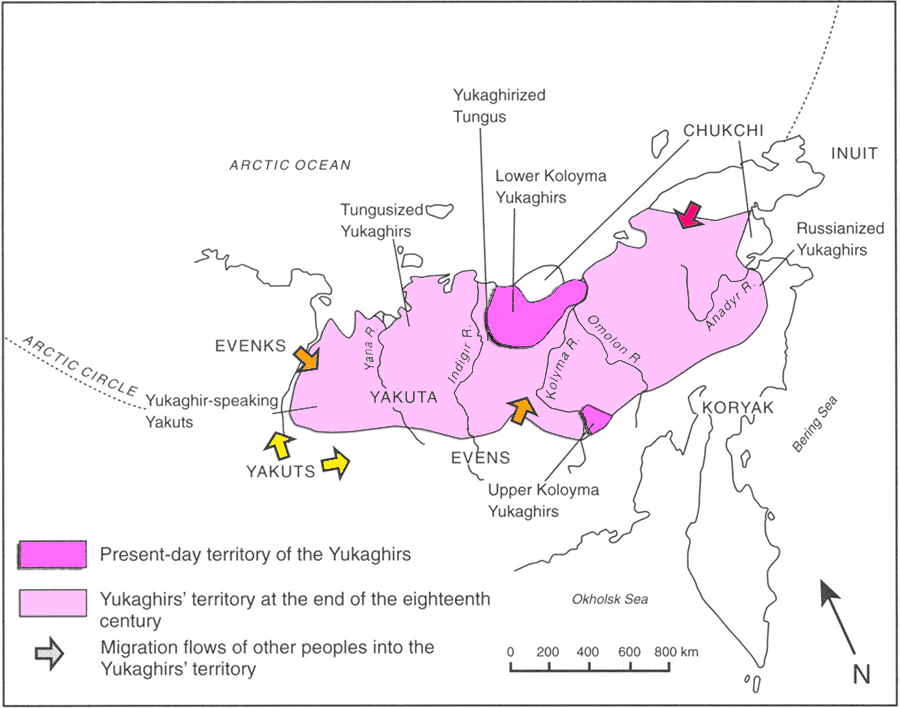
Map of the Yukaghirs’ territory and its complex recent evolution. Image modified from Willerslev (2004). The Young Yana River individual (ca. AD 1053-1259), sampled from a likely Yukaghiric-speaking region that might have begun receiving Yakut migrants in the 13th century, shows an ancestry suggestive of a recent Circum-Baikal-related admixture when compared to other Bronze Age and Iron Age individuals from the Russian Far East. What is more, its subclade N1a-M1991, from the N1a-M1993 branch (TMRCA ca. AD 650), derives from a parent N1a-M2058 that appears to have spread with Turkic-speaking peoples, being found to date in four ancient (non-elite) Magyars. Other ancient N1a-M2019 samples – and the currently incomplete phylogenetic picture of this haplogroup’s modern distribution in Yakutia – do not help clarify the situation (see map of ancient N-M2019 and timeline slideshow).
Yukaghiric hydronymy (see above) points to the Angara-Tunguskas river basins as the most likely Pre-Proto-Yukaghir area at the arrival of Pre-Proto-Samoyed in the early 2nd millennium BC. The superstratal (lexical) influence of Pre-PSmy. on Pre-PYuk. without a correlative influence of Yukaghir on PSmy. seems to constrain the Pre-PYuk. community to the border Cherkaskul areas far from the Minusinsk Basin, whereas the Yeniseian substrate of Yukaghir points to a fairly western location between the basins of the Yenisei and Lena rivers. Both influences appear to delimit the Pre-PYuk. area in time and space to the Serovo-related traditions of the Kansk-Rubyn Basin.
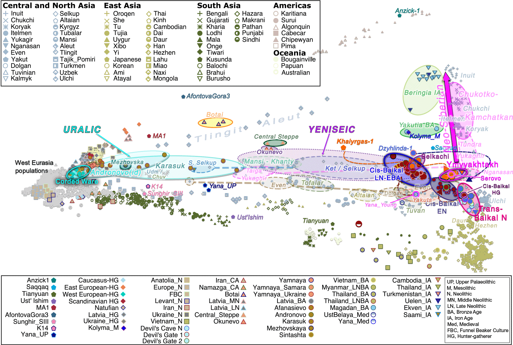
PCA from Kılınç et al. Sci Adv (2021), calculated using a set of world populations. Ancient individuals were projected onto the inferred PC space. Arrows indicate the direction of population changes in time for Cis-Baikal, Trans-Baikal, and Lena-Kolyma populations. Notice ancient west-east cline of CWC-related (Ugric and Samoyed) vs. Baikal-related (Yeniseian-Yukaghir) ancestries, connected by intermediate modern acculturated Siberian populations influenced by (‘northern’) local ancient Siberian-related ancestry and (‘southern’) Turkic, Tungusic, and Mongolic-related ancestry. Despite the tight genetic relationship of Serovo-related kra001 with Ymmyakhtakh, the expansion of the latter predates the Pre-Proto-Samoyed expansion into South Siberia. It is therefore very likely that the Proto-Yukaghir population that gave rise to the attested language family spread with post-Ymyyakhtakh cultures of Yakutia, such as Ust-Mil. The finding of different successive waves of genetic replacements from (south-)west to (north-)east in Yakutia contradicts the traditional (post-)Soviet continuist picture of Neolithic archaeological cultures of Siberia (e.g. for Yukaghir the recent Nemirovskij 2017).
In fact, sampled Taiga Yukaghirs show an intermediate ancestry between Khants and Kets-Selkups, despite living far apart from these populations (cf. the recent Starostin et al. bioRxiv 2021), and the sampled Evens clustering close to them might give support to an origin of their common ancestry in an Iron Age population movement close to the Angara River Basin. In that case, this cluster would have formed by the admixture of Cherkaskul/Karasuk-related incomers with local populations of the Kansk-Rubyn or Angara-Lena basins, supporting that Pre-Proto-Yukaghir spread with Serovo-related ancestry (and Y-DNA bottlenecks?), whereas the ancestry of Tundra Yukaghirs reflects an underlying acculturated Ymyyakhtakh-related population.

Join the discussion...
It is good practice to be registered and logged in to comment.Please keep the discussion of this post on topic.
Civilized discussion. Academic tone.
For other topics, use the forums instead.