New paper (behind paywall) Climate and Vegetation Changes over the Past 7000 Years in the Cis-Ural Steppe, by Khokhlova, Morgunova, Khokhlov, and Gol’eva, Eurasian Soil Sc. (2018) 51: 506.
Abstract (emphasis mine):
A multilayered archaeological site Turganik Settlement in the valley of the Tok River in the Cis- Ural steppe (Orenburg oblast) was examined with the use of paleopedological and microbiomorph methods. Ancient people inhabited this area in the Latest Neolithic (Eneolithic) (5th millennium BC) and Early Bronze (4th millennium BC) ages. It was found that cultural layers dating back to the Atlantic period of the Holocene had been formed under conditions of a predominance of grassy–forb vegetation with a small portion of tree species and dry climate; the ancient settlement was not affected by floods and was suitable for permanent living. It is probable that soils of the chestnut type with salinization and solonetzic features were developed in that time. The final stages of the accumulation of cultural layers were marked by strong shortterm floods, whose sediments partly masked the features of the previous long arid epoch. The highest degree of aridity was at the end of the Atlantic period. In the Subboreal and Subatlantic periods, soils of the meadowchernozemic type were formed; the spore–pollen spectra of these periods are characterized by a higher portion of tree species and by the presence of phytoliths of meadow grasses. The climatic conditions were generally colder and more humid, though some short-term aridization stages could take place. Some of these stages are recorded in the thickness of the studied sediments.
Interesting excerpts:
Paleosols buried under archaeological monuments of different periods represent a valuable archieve of information about the paleoenvironment. Most of the works in the field of archaeological pedology deal with earthen burial sites and kurgans [2, 5, 7, 9, 11]. Paleosols buried under the kurgans present us the paleoenvironmental records of a relatively short time before they were buried under the kurgan bodies. The study of kurgans created in different times makes it possible to characterize paleosol sequences storing information on longer periods of time in the second half of the Holocene. However, groups of kurgans that were consecutively created during the entire time span of kurgan construction, beginning from about 6000 yrs BC to the Early Medieval epoch, are few in number [8, 18, 22]. Even for such groups of kurgans, there are considerable time intervals that cannot be characterized because kurgans were not constructed during them. Hence, it is impossible to study the soils buried during these intervals. To reconstruct paleoenvironmental conditions for them, certain interpolation is required [29].
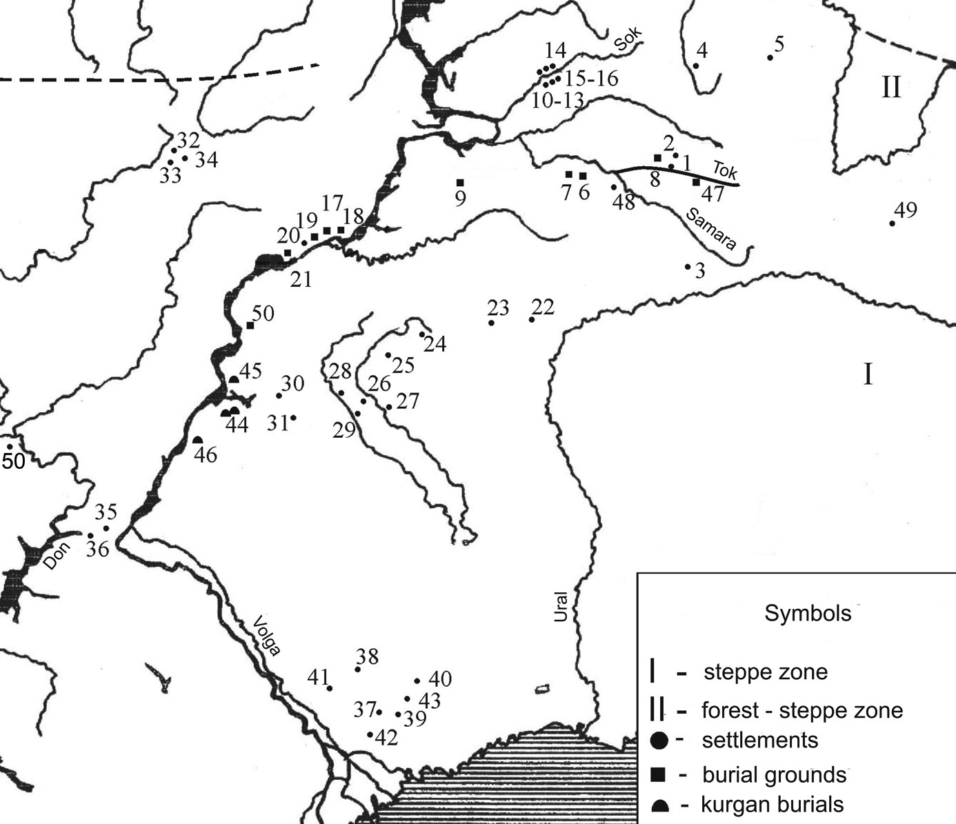
At the same time, there are archaeological sites — ancient settlements — the material of which gradually accumulated during very long time, e.g., beginning from the Middle Holocene to the present. Though such objects may also contain “missing layers” for certain periods, when the processes of denudation, erosion, or deflation predominated over sediment accumulation, they represent an almost continuous record on information about the paleoenvironmental conditions from the beginning of their functioning [25]. The most valuable among such sites are those that retain information on those periods of the Holocene that cannot be characterized on the basis of available data on the paleosols buried under the kurgans. In particular, this is the Atlantic period (7500–5000 yrs ago), because the construction of kurgans began only in the second half of this period (within the Volga–Ural interfluve [14]), and such ancient kurgans are rarely found. We studied such an archaeological site in the valley of the Tok River in the Cis-Ural steppe zone in Orenburg oblast. This site is known as the ancient Turganik settlement.
We studied different layers of the Turganik settlement with the use of a set of methods in order reconstruct the paleoenvironmental conditions (climate and vegetation) for the entire period of the accumulation of these sediments.
Thus, the Atlantic period of the Holocene in the Cis-Uralian steppe was characterized by dry climatic conditions with the driest stage during the Early Bronze Age (the Early Yamnaya culture of the middle of the fourth millennium BC). The Subboreal and Subatlantic periods were generally colder and wetter, though they also included short-term aridization phases, some of which were recorded in the sediment thickness.
This site is at the core of the interaction of Samara, Khvalynsk, and Repin cultures during the Eneolithic.
You can read more about it and the nature of Repin described by Morgunova (in favour of Gimbutas’ model), as combining traditions from Eneolithic steppe cultures from Khvalynsk to Sredni Stog, e.g. in Pottery from the Volga area in the Samara and South Urals region from Eneolithic to Early Bronze Age (2015).
The migration model of Anthony (2007, 2015), who collaborated with this group, is a more precise description of how peoples from the east of the Don River (mainly Khvalynsk/Repin cultures) migrated to develop a greater Yamna community, with Repin-type material culture expanding east of the Urals (into Afanasevo) and west of the Don River (into previous Sredni Stog/Kvitjana territory) – which I followed for the Indo-European demic diffusion model (we have recent samples of other potential Khvalynsk/Repin-related migrations).
NOTE. I usually refer to this Khvalynsk/Repin migration in genomics as of ‘Khvalynsk migrants’, for simplicity purposes, given that the few samples we have are from Khvalynsk, and that cultural regions east of the Don are difficult to differentiate precisely. However, it remains to be seen if – as I proposed – there are genetic differences between Repin and Khvalynsk groups, especially regarding R1b-L23 subclades – I proposed mainly Z2103 for Khvalynsk, L51 for Repin, a difference which has not been confirmed for the moment in Afanasevo, probably of Pre-Tocharian dialect, an archaic Northern dialect of Late PIE.
Anthony’s model of Khvalynsk/Repin as Yamna forefathers is probably, as we are seeing in Yamna samples, the right interpretation of peoples behind pots, compared to Gimbutas’ general idea of expanding kurgans of the 1970s.
On the other hand, the alternative Russian school version of Yamna developing from a heterogeneous community of Khvalynsk-Sredni Stog-Lower Danube cultures is probably by now to be fully dismissed, in archaeology (as Morgunova says) as in genetics.
Related:
- Steppe and Caucasus Eneolithic: the new keystones of the EHG-CHG-ANE ancestry in steppe groups
- The Caucasus a genetic and cultural barrier; Yamna dominated by R1b-M269; Yamna settlers in Hungary cluster with Yamna
- Differing modes of animal exploitation in North Pontic Eneolithic and Bronze Age Societies
- Consequences of Damgaard et al. 2018 (I): EHG ancestry in Maykop samples, and the potential Anatolian expansion routes
- On the potential origin of Caucasus hunter-gatherer ancestry in Eneolithic steppe cultures
- Eneolithic Ukraine cultures of the North Pontic steppe and southern steppe-forest, on the Left Bank of the Dnieper
- North Pontic steppe Eneolithic cultures, and an alternative Indo-Slavonic model
- No large-scale steppe migration into Anatolia; early Yamna migrations and MLBA brought LPIE dialects in Asia
- Proto-Indo-European homeland south of the Caucasus?