New paper (behind paywall) Where are the cereals? Contribution of phytolith analysis to the study of subsistence economy at the Trypillia site Maidanetske (ca. 3900-3650 BCE), central Ukraine, by Dal Corso et al. Journal of Arid Environments (2018).
Interesting excerpts (only introduction and conclusions, emphasis mine):
Archaeological setting at the site of Maidanetske, Ukraine
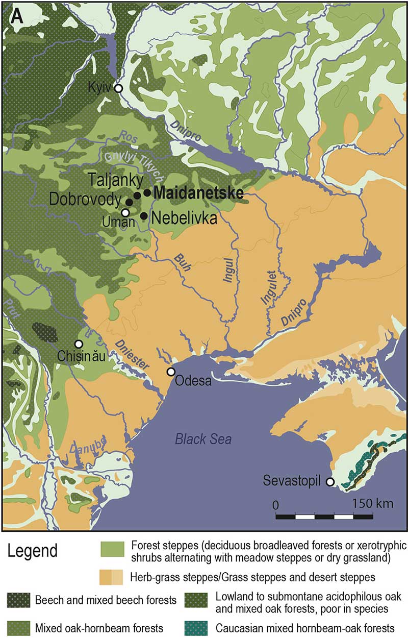
From ca. 4800 to 3350 BCE, Trypillia settlements were widespread over parts of eastern Romania, Moldova and Ukraine (Menotti and Korvin-Piotrovskiy, 2012; Müller et al., 2016; Videiko, 2004). Maidanetske (Fig. 1B) is one of the so-called “mega-sites” which developed during ca. 3900–3400 BCE in central Ukraine, in the Uman region (Cherkasy district) (Müller and Videiko, 2016; Müller et al., 2017). In this region, nine of these “mega-sites” have been found. Mega-sites are characterized by a regular plan with concentric rings of houses around a large empty central space, additional quartiers, with radial and peripheral track ways (Fig. 1B). The three mega-sites Maidanetske, Taljanky and Dobrovody, lay ca. 15 km apart from each other (Fig. 1A); other mega-sites are located within a 50 km radius around Maidanetske. Archaeologically, these mega-sites consist of the remains of buildings most of them burnt, although a minority of unburnt buildings is known of as well (Burdo and Videiko, 2016; Müller and Videiko, 2016; Ohlrau, 2015). Most of these buildings have a standardized regular size (average 6×12 m) and architecture including domestic installations and a standardized assemblage of artifacts. At Maidanetske beside normal sized houses there are few larger rectangular buildings that are located regularly along the main pathways. Further archaeological contexts include pits, pottery kilns, and peripheral ditches. A huge variety of mostly painted pottery (including many with figurative animal and plant motives), some flint artifacts, rare copper objects, querns, adzes and a broad range of anthropomorphic and zoomorphic figurines are attested within houses and mega-structures. In terms of organic remains, animal bones are fairly common, while botanical macro-remains appear to be scarce and poorly preserved (Kirleis and Dal Corso, 2016; Pashkevich and Videjko, 2006).
and Dreibrodt, 2016, graphic K. Winter, Kiel University).
Environmental setting at Maidanetske
The Trypillia sites in central Ukraine, including Maidanetske, are located in a semi-arid forest-steppe ecozone, a mosaic-like ecosystem stretched between the dry steppe grasslands in the south and temperate woodland biomes in the north (Fig. 1A). In this transitional zone the natural vegetation is supposed to be patchy and sensitive to climate and topography (Feurdean et al., 2015; Molnàr et al., 2012; Walter, 1974). Since most of the accessible plateaus are converted to agricultural land and the scarce broadleaf woodlands are managed, the natural landscape heterogeneity is difficult to trace within the current landscape (Kuzemko et al., 2014). Besides agricultural fields and villages, narrow river valleys incised into the loess plateaus are present, with riparian vegetation and artificial lakes. This western Pontic area has a humid continental climate with wet winters and warm summers (Köppen and Geiger, 1939), which corresponds to a semi-arid 0.2–0.5 aridity index value according to UNEP (1997). Nevertheless, the reconstruction of past climatic as well as environmental conditions is not straightforward, since undisturbed archives for pollen analysis are lacking in the region and published climatic reconstructions combine evidences from peripheral areas (Gerasimenko, 1997; Harper, 2017; Kirleis and Dreibrodt, 2016). In the Transylvanian forest-steppe region, palynological investigations suggest that dry grasslands have expanded since the end of the 4th millennium BCE, fostered by Bronze Age forest clearance, while before this the area was largely forested (Feurdean et al., 2015). In the Hungarian forest-steppe, the mixed oak forest on Loess almost disappeared by the end of the 18th century AD, hampered by factors such as fragmentation, slow regeneration, spread of invasive species and lowering of the water table due to increased aridity (Molnàr et al., 2012). It is clear that forest-steppe environments are very sensitive to aridity and land use practices. To understand whether similar landscape change can have occurred in central Ukraine already at the time of Chalcolithic mega-sites, an understanding of the extent of crop growing and deforestation is crucial.
The site of Maidanetske is situated on a plateau covered by Loess deposited during the Last Glaciation. This plateau is dissected by valleys of different sizes with perennial rivers present within the large valleys. One of these rivers passes the site in a distance of less than 500 m. The soils that are present nowadays are Chernozems. They show dark greyish-brown A-horizons of thicknesses between 30 and 50 cm and a texture dominated by silt. Numerous filled crotowinas indicate an intensive bioturbation during the formation of these soils. The Chernozems cover the archaeological record. The variations in thickness of the A-horizon are probably reflecting post-depositional soil erosion processes. Buried soils discovered at lower slope positions below colluvial layers show properties of Cambisols, thus pointing towards a forested past of the surrounding landscape (Kirleis and Dreibrodt, 2016).
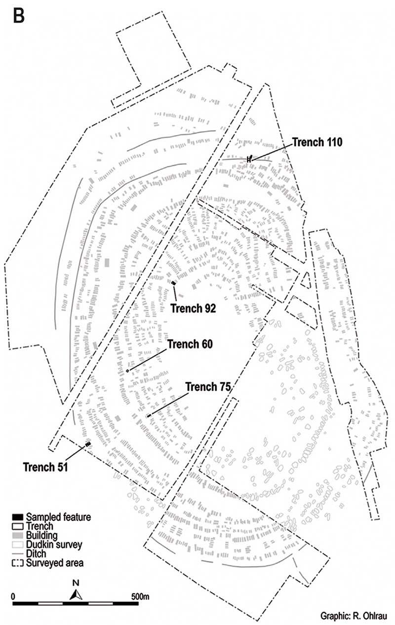
Dudkin), with the position of the trenches mentioned in this study.
Conclusion
At the site of Maidanetske, the phytolith record from different contexts including multiple houses, was studied, which confirmed cereal cultivation as part of the subsistence economy of the site. Furthermore, phytoliths gave information about wild grasses, whereas dicotyledonous material was scarce. For the house structures cereal byproducts, chaff and straw were identified as material selected for tempering daub for the wall construction. Ash layers in a pit filled with house remains show similar pattern. Daub fragments and pit filling are the most promising archives for further phytolith work on cereals at Trypillia sites. The sediment inside four burnt houses and the areas outside two houses, where also grinding stones were sampled, showed little presence of the remains of final cereal processing, suggesting that either the surfaces were cleaned and the chaff was collected after dehusking, or the cereal processing activity took place somewhere else. Specific archaeological contexts, such as vessels and grinding stones, did not differ much from the control samples from archaeological sediment nearby, suggesting disturbance of the record.(…)
Related
- About Scepters, Horses, and War: on Khvalynsk migrants in the Caucasus and the Danube
- Steppe and Caucasus Eneolithic: the new keystones of the EHG-CHG-ANE ancestry in steppe groups
- The Caucasus a genetic and cultural barrier; Yamna dominated by R1b-M269; Yamna settlers in Hungary cluster with Yamna
- Consequences of Damgaard et al. 2018 (I): EHG ancestry in Maykop samples, and the potential Anatolian expansion routes
- On the potential origin of Caucasus hunter-gatherer ancestry in Eneolithic steppe cultures
- Eneolithic Ukraine cultures of the North Pontic steppe and southern steppe-forest, on the Left Bank of the Dnieper
- North Pontic steppe Eneolithic cultures, and an alternative Indo-Slavonic model
- The concept of “Outlier” in Human Ancestry (III): Late Neolithic samples from the Baltic region and origins of the Corded Ware culture
- New Ukraine Eneolithic sample from late Sredni Stog, near homeland of the Corded Ware culture
- The renewed ‘Kurgan model’ of Kristian Kristiansen and the Danish school: “The Indo-European Corded Ware Theory”